|
|
LOST
AREAS
Americana
+ - still open as
Mountain
Top at Grand Geneva, was also
called Indian Knob, Playboy Club, and Hotdog
Mountain
- Playboy Club became Americana in
1980
Baldy
Mountain Ski Hill (Old
Baldy)
- Cornell, WI - northwest Wisconsin
- adjacent to the Chippewa County Forest, a few miles
west of Cornell
- v: 150 ft. 1 rope tow
- Google
Maps / Google
Earth
45.207497755530724, -91.27312637192851
- Lost Wisconsin Ski Areas Facebook
Page 1
2
Badlands
Baird's
Creek+
- see Moon
Valley, still open as
Triangle
Sports Area
Bay
View Hill
* see Williams
Bay Ski Hill
Bear
Valley
* (see Pink
Panther)
Big
Bearskin Lake Ski Hill
- Oneida County, Rhinelander /
Tomahawk , WI - north central Wisconsin - On Big Bearskin
Lake 20 miles west of Rhinelander, and 20 miles north of
Tomahawk - 2 to 3 miles north of Goodnow on old
51
- o: 1945
- upside
down (lodge at the
top)
- Google
Maps / Google
Earth (Bearskin Lake)
45.73383865844644, -89.67992937155978
- advertisment
- The Rhinelander Daily News, Feb 25, 1946
- Winter
Activites To Start Sunday at Bearskin
Hill - The Rhinelander
Daily News, Dec 18, 1947
- Big
Bearskin Ski Facilities Open
- The Rhinelander Daily News, Dec 30, 1948
- Lost
Wisconsin Ski Areas Facebook Page
Big
Dipper Ski Hill
* - see
Echo
Valley
Big
Hill Memorial Park
^ - ski jump only
Birch
Haven (originally called
Suicide Hill)
- Baraboo, WI - south central
Wisconsin - Midway between Sauk City and Baraboo, 1 and
1/2 miles west of Badger Ordnance Plant on County C, two
miles west of Bluffview, E 10389 County Rd. C
- v: 278 ft. o: 1954
- Google
Maps / Google
Earth
43.35721553820846, -89.80622165921609
Please email - mark@mwlsap.org - if you know a more
precise location.
- Lost Wisconsin Ski Areas Facebook
Page (Birch Haven) 1
2
3
4
5
6
- Skiers
and Snowboarders of the Midwest Facebook
Group
- skimap.org
Birch
Park (also called Eight
Flags of Birch Park)
Birchwood
Valley
- Sparta, WI - west central
Wisconsin - 4 1/2 miles north on county B on
Monroe
County Forest-Lafayette
land
- c: 1976
- Google
Maps / Google
Earth
44.0076244248097, -90.79491926463723
- "Explorer Scouts, under the
direction of Rich Helm, constructed, maintained and
operated the project over the past year, but say they
can't continue." - The
La Crosse Tribune (La Crosse, Wisconsin) · Sun, Apr
29, 1973
- Explorers,
Girl Scounts Attend Winter
Activity - The La Crosse
Tribune (La Crosse, Wisconsin) · Thu, Jan 20,
1972
- Board
Votes to Prohibit Commercial Game
Farms - The La Crosse
Tribune (La Crosse, Wisconsin) · Thu, Sep 6, 1973
·
- Monroe
County Accepts $228 Million
Valuation - The La Crosse
Tribune (La Crosse, Wisconsin) · Thu, Oct 4, 1973
- Monroe
County OKs Funds To Finish Dam
- LaCrosse Tribune, Oct. 9, 1976
Boulder
Junction
Buffalo
Valley Inc.
* became Hiawatha
Hills
Bull
Run Ski Area
Calumet
County Park (previously
called Calumet Hills, also Fox
Valley Ski Club)
Chain
O' Lakes
Chanticleer
Inn
Coon's
Hill
Crystal
Ridge+
- still open as Rock
Snowpark; renamed Crystal
Ridge 2024
Currie
Park
Deepwood
(may be reopening as Woodwind
Park)
Deer
Trail
Delafield
Lodge*
(see Velkommen)
Dell
View Hotel
(Williamson's Dell View Hotel)
- Lake Delton / Wisconsin Dells, WI
- central wWisconsin
- 2 rope tows and a ski instructor
at hotel on Lake Delton
- Google
Maps / Google
Earth
43.60633255078956, -89.77773411841439
On Lake Delton
Please email - mark@mwlsap.org - if you know a more
precise location.
- Ad in Central
Skiland, Dec. 1966, page 40
- Milwaukee
Road Will Run Package Jaunts
- Portage Daily Register (Portage, Wisconsin) · Thu,
Dec 9, 1965
- From The
Winter Sports Guide 1966-1967
Milwaukee road Railroad
- Dells
Year-Around Fun Spot -
Wisconsin Dells Events (Wisconsin Dells, Wisconsin)
· Thu, Jan 22, 1970
- Mall
Merchants To Offer Winter Weekend
Vacation - The Sheboygan
Press (Sheboygan, Wisconsin) · Thu, Jun 18,
1970
Dellwood
Ski Area ??? -
probably Deepwood
- Colfax, WI - west central
Wisconsin
- Google Maps / Google
Earth
- Ski
Reports - Minneapolis Star,
Feb. 18, 1960, p. 52
- This is the only reference that
could be found. May be a misprint.
Devil's
Lake - Windy City Ski Club
* - see Windy
City Hill
Dretzka
Park
Dyracuse
Mound
Eagle
Bluff Ski Area
Eagle
or Eagle
Springs
- Eagle, WI, Waukesha County -
southeast Wisconsin
- Google
Maps / Google
Earth
42.85319071208946, -88.46010998070847
"About the ski hill at Eagle: It sat on the land where
the Eagle Springs Golf Course is now, off of Cty. Hwy Lo.
It looks like the only way they could've had 100 vertical
feet was with a south-facing slope. The rail line ran
right next to it. " message from Mick Shoup
??? "possibly on the Orin Benson property N of Eagle"
from the Waukesha County Historical Society & Museum
via email)
- Wisconsin
Plans Festive Winter Sports
Program - Chicago Tribune
(Chicago, Illinois) · Wed, Jan 15, 1941
- Sports
in the Snow - Waukesha
Daily Freeman (Waukesha, Wisconsin) · Fri, Jan 3,
1947
- Relax
in Waukesh County, 1948
tourist brochure - Thank you to the Waukesha County
Historical Society & Museum
- Waukesha
Daily Freeman (Waukesha, Wisconsin), Sat, Jan 24,
1948 ·
- Lost Wisconsin Ski Areas Facebook
Page: Two
ski hills near Eagle, WI
Eau
Claire Winter Sports Club Ski
Hill *
- see Pinehurst
Echo
Valley (see
Big Dipper
Ski Hill)
- White Lake, WI - Echo Valley
Resort - northeast Wisconsin - 7 mi. W of Mountain,
WI
- v: 70 ft. o: 1969 c:
1977
- on maps: 1969;
1971;
1973;
1977
- advertisement
- Green Bay Press Gazette, Dec. 7, 1969
- Google
Maps / Google
Earth
45.152794970135105, -88.62397655592368
- Skiers and Snowboarders of the
Midwest Facebook Group - Explored
one of the smaller lost Wisconsin ski
areas.
- Lost Wisconsin Ski Areas Facebook
Page 1
2
- 54
Wisconsin Ski hills 'Better Than
Ever' - Green Bay
Press-Gazette (Green Bay, Wisconsin) · Sun, Dec 3,
1972
- State
downhill ski areas listed -
The Daily Tribune (Wisconsin Rapids, Wisconsin) ·
Sat, Nov 8, 1975
Eight
Flags of Birch Park*
- see Birch
Park
Elpa
Lodge Slopes,
- Slinger, southeast Wisconsin -
7
mi. SW of Slinger
- Google
Maps / Google
Earth ??
location of Slinger
43.334128958557365, -88.2757852204042
Holy Hill / Heiliger
Huegel is in this
loctaion
Please email - mark@mwlsap.org - if you know a the
location.
- 1951-52
Directory Winter Sports
Playgrounds, Chicago and
North Western Railroad
- Chicagoland
Boasts Many Ski Areas -
Chicago Tribune, Sun, Feb 3, 1952
- Outdoor
Sports in full Swing in State With Snow, Cold
Weather - The Oshkosh
Northwestern, Dec. 18, 1954
- Ski
Anywhere in Wisconsin ;Choice Includes 50
Resorts - The Daily Tribune
(Wisconsin Rapids, Wisconsin) · 3 Jan
1958
Engelwood
Fawn
Lake Lodge
Ferry
Hill Winter Sports Area
- Lodi, WI (Okee) - south central
Wisconsin - south of the Merrimac ferry, and two miles
west of Okee off of Highway 113 and County V, near
Gibralter Rock
- o: 1956
- Google
Maps / Google
Earth ???
43.35667529337323, -89.61170554743344
Please email - mark@mwlsap.org - if you know a more
precise location.
- Lost
Wisconsin Ski Areas Facebook Page
The
Flats - The Kiwanis Club
of Oconto Falls
Forest
Lake Ski Bowl
- Campbellsport, WI - southeast
Wisconsin, on Cranberry Lake (?), 5 mi from junction of
45 and 67, county trunk SS at the Sheboyban-Fond du Lac
county line; Kettle Moraine North Unit
- v: 175 ft. o: Jan. 19,
1941
- Google
Maps / Google
Earth
43.60802364958532, -88.16743326371048
(Forest Lake)
- Ski
Bowl In K-M Area Is Going Strong
- The Sheboygan Press (Sheboygan, Wisconsin) · Wed,
Jan 22, 1941
- Civilian
Defense Ski Corps Formed In The Kettle
Moraine - The Sheboygan
Press · 24 Jan 1942
- Southern
Wisconsin Gains Fame As Year Round Resort Area; Winter
Sports Boom - Janesville
Daily Gazette, Jan 9, 1948
Fox
Valley Ski Club * -
see Calumet County Park
Fun
Valley Ski Area
Frolic
Valley
Gateway
Lodge -
same as King's
Gateway?
Glenwood
City 57 Hills Ski Area
* - see Ski
Glen
Greenbush
Ski Hill
- Campbellsport, WI (Kettle Moraine
North Unit) - southeastern Wisconsin - east
facing
- v: 125 ft; 1940s -
1979
- upside
down - parking at top,
lodge at the bottom
- In 1978 (Skalka):
2 rope tows
- Google
Maps / Google
Earth
43.74618283689311, -88.1006569359049
- Ski
Tow, Wide Trails, Please
Enthusiasts- Wisconsin
State Journal (Madison, Wisconsin) · Sun, Feb 11,
1951 - pictures
- Calumet,
Greenbush Ski Hills - The
Sheboygan Press (Sheboygan, Wisconsin) · Tue, Jan 7,
1958
- Lost
Ski Areas of Wisconsin Facebook Page
- SKI
Magazine - Jan. 1979
(link)
- Skiers
and Snowboarders of the Midwest Facebook
Group
- skimap.org
Hagen-Miner
+ probably the same as Mt.
Hardscrabble
- Rice Lake, WI
- Rice
Lake Winter Sports Firm Forms
- The Daily Telegram (Eau Claire, Wisconsin) · Tue,
Jul 3, 1951
- Ski
Reports - Star Tribune
(Minneapolis, Minnesota) · Fri, Feb 8, 1952
- Area
Skiing Rated Good - The
Daily Tribune (Wisconsin Rapids, Wisconsin) · Fri,
Jan 30, 1953
- Wisconsin
Lost Ski Areas Facebook Page
- Mt Hardscrabble - mentions owner Cap Hagen
Hardscrabble
Harrison
Hills (later called Silver
Valley)
Hazelhurst
Hiawatha
Hills
(Buffalo Valley Inc.) / Hiawatha Valley
- between Cochrane and Alma, WI -
west central Wisconsin
- v: 600 ft. (551 ft) o: 1970 c:
1975
- Google
Maps / Google
Earth
44.274248368740686, -91.88003874247669
- Skiers
and Snowboarders of the Midwest
- Facebook Group
- Lost Wisconsin Ski Areas Facebook
Page 1
2
- also see Buffalo
Valley Inc.
- skimap.org
- Buffalo
Valley Men go to Work On Midwest Recreation Plan
- The Winona Daily News
(Winona, Minnesota) · Sun, May 10, 1964
- Dale
Denies Bankrupcy Claim -
Waukesha Daily Freeman (Waukesha, Wisconsin) · Thu,
Jun 26, 1975 [third column mentions ski hill running
for a couple of years)
- Hiawatha Valley - A
week's lessons takes minutes
- The Winona Daily News (Winona, Minnesota) · Sun,
Jan 30, 1972
- skimap.org
Hiawatha
Slopes
Hidden
Valley Ski Area
Highlands
of Olympia
* (See Olympia)
Hilly
Haven Ski and Golf
Hogsback
Hill
Hogsback
Springs Recreation Area
* (see Spur
Lake Recreation Area)
Holiday
Hill
- Lake Geneva, WI - southeast
Wisconsin
- 3 miles from Lake Geneva on hwy
36 (1952) - current hwy 120
- about 1 1/2 mi E of Lake Geneva
,
- 2 mi from C & NW RR station
at North and Broad Sts. - this brings us just past the
Verlo Mattress Factory on Hwy 120 (old 36) Near
Mt
Fuji.
- v: 200 ft.
- Location?
- Possibly the current #3 hole of
the Como Crossing Course at Hawk 's View Golf Course
(but only about 80 ft. vertical)
Google
Maps / Google
Earth
|42.61803917793222, -88.41845639271455
- Verlo Mattress:
Google
Maps / Google
Earth
42.61663105793073, -88.41533881738056
- Mt. Fuji:
Google
Maps / Google
Earth
42.62171191893715, -88.4262207982156
- Please email - mark@mwlsap.org
- if you know a more precise location.
- 1956
map
- Midwest
Set for a Banner Year in Snow
- Chicago Tribune (Chicago, Illinois) · Sun, Dec 8,
1946
- Southern
Wisconsin Gains Fame As Year Round Resort Area; Winter
Sports Boom - Janesville
Daily Gazette, Jan 9, 1948
- Skiing
At Holiday Hill Proves Popular Pastime for Many
- The Lake Geneva Regional
News, Jan 17, 1952
- Outdoor
Sports in Full Swing in State With Snow, Cold
Weather - The Oshkosh
Northwestern, Dec. 18, 1954
- 1951-52
Directory Winter Sports
Playgrounds, Chicago and
North Western Railroad
- Chicagoland
Boasts Many Ski Areas -
Chicago Tribune, Sun, Feb 3, 1952
Hotdog
Mountain
* (also called Indian Knob,
Playboy Mountain, Mt. Playboy, Hotdog Mountain, Americana)-
still open as Mountaintop
at Grand Geneva
Indian
Knob
* (also called Americana,
Playboy Mountain, Mt. Playboy, Hotdog Mountain) - still open
as Mountaintop
at Grand Geneva
Interlaken
Resort
Iola
Iverson
Park
Johnson
Park
Kettle
Moraine South Unit
(Scuppernong)
- Eagle WI - southeast Wisconsin;
"near
headquarters off hy. zz"
1954
- Google
Maps / Google
Earth
42.94223787904681, -88.4483225759862
Thank you to Scott Danforth
- Beautiful
Kettle Moraine Drive Offers Classic Chance for Nature
Study; Extends 35 Miles through
County - Waukesha Daily
Freeman (Waukesha, Wisconsin) · Wed, Jun 23,
1954
- "Winter sports enthusiasts will
find a downhill ski run and ski tow developed near the
headquarters station located off hy. zz."
- Rib
Mountain Beckons Skiers -
Wisconsin State Journal (Madison, Wisconsin) · Sun,
Dec 30, 1956
- "In the Greenbush area of
Kettle Moraine are two ski runs while in the 'southern
purchase' area near Milwaukee and Waukesha, there is a
single ski run and tow."
- Some current photos (2025)
1-pole
for rope tow? /
2
- lamp on a pole (Thank you
to Scott Danforth
- Lost Wisconsin Ski Areas Facebook
Page
- Skis,
Skates, Snowshoes Eyed Expectantly In State As Another
Season Soon Rolls 'Round -
The La Crosse Tribune (La Crosse, Wisconsin) · Sun,
Nov 6, 1949
- You
can snowmobile, ski, toboggan in county
- Waukesha Daily Freeman
(Waukesha, Wisconsin) · Sat, Feb 9, 1974
King's
Gateway
- same as Gateway
Lodge?
- Land O' Lakes, WI - far north
central Wisconsin - one-half mile from the Gateway Lodge,
east of Highway 45
- o: 1950s v: 110ft
- Google
Maps / Google
Earth
46.159566398525534, -89.20873415658703 (Gateway
Lodge)
Please email - mark@mwlsap.org - if you know a more
precise location.
- Lost
Wisconsin Ski Areas Facebook Page
- read first paragraph, 2
much better
- Ski
Train Will Run On Sunday -
Green Bay Press Gazette, Feb. 16, 1940
- Midwest
Set for a Banner Year in Snow
- Chicago Tribune (Chicago, Illinois) · Sun, Dec 8,
1946
- 1951-52
Directory Winter Sports
Playgrounds, Chicago and
North Western Railroad
- Oneida,
Vilas Winter Sports Areas Featured
- The Rhinelander Daily
News · 13 Dec 1950
- On
1972 map - Lost Wisconsin
Ski Areas Facebook Page
- Williamson
Sell Famous Resort -
Wisconsin Dells Events (Wisconsin Dells, Wisconsin)
· Thu, Jul 26, 1973
Kiwanis
Park (Kiwanis Hill) -
Ripon
La
Crosse Snow Bowl
Lake
Arrowhead Resort
Lake
Lawn Hotel / Ski Farm
- Delavan, WI - southeastern
Wisconsin
- v:100 ft.
- Google
Maps / Google
Earth
42.62764267175873, -88.59980991277443
- 1956
map
- Midwest
Set for a Banner Year in Snow
- Chicago Tribune (Chicago, Illinois) · Sun, Dec 8,
1946
- Southern
Wisconsin Gains Fame As Year Round Resort Area; Winter
Sports Boom - Janesville
Daily Gazette, Jan 9, 1948
- Outdoor
Sports in full Swing in State With Snow, Cold
Weather - The Oshkosh
Northwestern, Dec. 18, 1954
- 1951-52
Directory Winter Sports
Playgrounds, Chicago and
North Western Railroad
Lapham
Peak (Government
Hill?)
Lincoln
Hills School for Boys
Little
Sun Valley
- Cresent, WI (6 miles of west of
Rhinelander / Tomahawk) - north central Wisconsin - not
far from where Camp 10 eventually located
- Google
Maps / Google
Earth
6 mi. W of Rhinelander:
45.589539083347375, -89.563331625996
- Little
Sun Valley Ski Tow In Operation
- The Rhinelander Daily News, Feb. 21, 1942
- Skiers
Have A "Ride Share" Plan -
The Rhinelander Daily News, Jan. 9, 1943
- Skiing
To Open At 'Sun Valley' And Rib
Mountain - The Rhinelander
Daily News, Dec. 7, 1942
- Southern
Wisconsin Gains Fame As Year Round Resort Area; Winter
Sports Boom - Janesville
Daily Gazette, Jan 9, 1948
- Lost
Wisconsin Ski Areas Facebook Page
- read first paragraph
Little
Swiss Valley *(see
Velkommen)
Lockhaven
(also called Spooner-Shell Lake Ski Area)
Lodi
See and Ski
Machickanee
Winter Sports Area
Majestic
(Majestic Hills, Majestic Ski Area, Ski Majestic)
Manitou
Valley Ski Valley
Maple
Crest Ski Tow
- Jeffris, WI - north central
Wisconsin (10 miles south of Rhinelander on
17)
- Google
Maps / Google
Earth
45.50199175185563, -89.43044775717503 Jeffris,
WI
- Lost Wisconsin Ski Areas Facebook
Page 1
2
- advertisement
Maryhill
+
- currently open as
Ausblick
(private) located on Maryhill Rd., Sussex, WI
Mineral
Point
Minocqua
Winter Park *- see
Squirrel
Hill
Moccasin
Snow Bowl
Moon
Valley
+ (Moon Valley Ski
Club) - (still open as Triangle
Sports Area - originally at
Baird's
Creek, then moved to
Fun
Valley Ski Area)
Mo-Ski-Tow
Hill
(Mosquito Hill)
Mt.
Atlanta
+ - still open as
Christie
Mountain
Mt.
Fuji
- Lake Geneva, WI - southeastern
Wisconsin - now Hawks View Golf Club
- v: 235 ft. o: 1960 c:
1970
- In 1978 (Skalka):
2 rope tows, 1 T-bar,
- Google
Maps / Google
Earth
42.62171191893715, -88.4262207982156
- $500,000
Ski Hill Planned North of Lake
Geneva - Janesville Daily
Gazette, 7 Apr 1961
- SKI
Magazine, Jan. 1978 - (link
- scroll down)
- short
history - Hawk's View Golf Club
- Mount
Fuji Has A Charm All Its Own
- Chicago Tribune (Chicago, Illinois) · 10 Mar
1967
- New
Ski Facilities - Sports
Illustrated, Dec. 4, 1961
- A
look back at Lake Geneva’s Mount Fuji (Where Hawk's
View is now located) -
lakegenevanews.net
- Hawk's
View Golf Club History -
LOTS OF PICTURES
- skimap.org
(0 maps)
Mt.
LeBett
Mt.
Ole ?
Mt.
Redstone
Mt.
Telemark
* (see Telemark)
Mt.
Tom (private)
- Burlington, WI - southeast
Wisconsin
- v: 175 ft.
- Google
Maps / Google
Earth
42.655958321401805, -88.19042027388242
- Racine Ski Club
- Mount
Tom - Home grown ski hill caters to
families - The Journal
Times (subscription)
- Racine
Ski Club Grows Over 30-Year Period
- The Racine Journal-Times Sunday Bulletin (Racine,
Wisconsin) · Sun, Jan 29, 1956
- Families
on Skis at Home on Mt. Tom
- The Journal Times (Racine, Wisconsin) · Sun, Jan
25, 1970
- The
Mt. Tom ski jump
- Mount
Tom, Racine County, WI -
mountainzone.com
- skimap.org
(0 maps)
Mus-Ski
Mountain (also
called Muskellunge)
Navarino
Hills (previously known as
Pues Hill)
Nemadji
Hill
Nest
Of Eagles
New
Munster Ski Hill
- Genoa City / New Munster, WI -
southeast Wisconsin - S of New Munster off of county rd.
KD, probably in what is now the New Munster Wildlife
Area; bowl-like
- 8 miles from Lake Geneva, 5 mi NE
of Genoa City
- v: 200 ft. 2 rope tows in 1946,
1948
- Google
Maps / Google
Earth ??
42.5527958681488, -88.23300578521189
- 1956
map
- Midwest
Set for a Banner Year in Snow
- Chicago Tribune (Chicago, Illinois) · Sun, Dec 8,
1946
- Southern
Wisconsin Gains Fame As Year Round Resort Area; Winter
Sports Boom - Janesville
Daily Gazette, Jan 9, 1948
- 36
Wisconsin areas Open to Winter
Sports - Chicago Tribune
(Chicago, Illinois) · Sun, Dec 9, 1951 (ski jump
too)
- Outdoor
Sports in full Swing in State With Snow, Cold
Weather - The Oshkosh
Northwestern, Dec. 18, 1954
- 1951-52
Directory Winter Sports
Playgrounds, Chicago and
North Western Railroad
Nor-Ski
Ridge (became
Omnibus)
North
Hills (North Hills Ski
Club)
- Fort Atkinson, WI - south central
Wisconsin - 1 mile N off of highway 89 (County Q)
- v: 130 ft. c: 1999 (?)
- faced east, accessed from county
road from the west
- upside
down
- Google
Maps / Google
Earth
42.957064957396696, -88.83392138296104
- on 1969,
1970,
and 1971
maps
- North
Hills Ski Club -
hoardmuseum.org
- on
- Skiing
Site Near Fort Offers Tow -
Janesville Daily Gazette, Feb. 9, 1951
- Janesville
Daily Gazette, Jan. 29, 1953
- Ski
Hills Listed In Directory -
Stevens Point Journal, Nov. 21, 1963
- Many
Ski Resorts Nearby When Weather
Cooperates - Dubuque
Telegraph Herald, January 02, 1966 Pg. 28, Dubuque, Iowa,
US
Northernaire
Resort
- Three Lakes, WI - north central
Wisconsin
- Owners of the Northernaire Resort
also owned the nearby Sheltered Valley Ski Area. They had
a beginner hill with tow rope at Northernaire
- Google
Maps / Google
Earth
45.79454326214343, -89.10531399361685
- 1951-52
Directory Winter Sports
Playgrounds, Chicago and
North Western Railroad
- advertisement
- Star Tribune (Minneapolis, Minnesota) · Sun, Dec
2, 1951
- Three Lakes - Going
Skiing? Make Your Reservations by This
List - The Rhinelander
Daily News, 23 Dec 1953
- Outdoor
Sports in full Swing in State With Snow, Cold
Weather - The Oshkosh
Northwestern, Dec. 18, 1954
- Lost
Wisconsin Ski Areas Facebook Page
Norway
Basin+
(formerly Sutter's Ridge, still open as Tryol
Basin)
Nutt
Hill
Oak
Ridge Ski Hill (Oak
Ridge Ski Club)
- Three locations:
- Riverside Park, Janesville, WI
- moved to "Scott Hill" (owned by
Ray Scott) on City Highway 14 beyond Riverside Park,
north of Janesville, WI (1962-1975)
- moved to Serns Road, (between
County N and John Paul Road) North of Milton, WI in
1976
- private
- Locations
- Riverside Park, Janesville
Google
Maps / Google
Earth
42.70758133450376, -89.03974782380266
- Scott Hill
Google
Maps / Google
Earth ???
42.72115984228944, -89.0615675070257
Please email - mark@mwlsap.org - if you know a more
precise location.
- Sterns Road, North of
Milton
Google
Maps / Google
Earth
42.811338532794515, -88.95682803040512
Please email - mark@mwlsap.org - if you know a more
precise location.
- Lost
Wisconsin Ski Areas Facebook Page
2
- Then
and Now: Oak Ridge Ski Club
- gazetteextra.com
- Oak
Ridge Ski Club: Do-It-Yourseft
Tale - Janesville Daily
Gazette, Feb. 20, 1969
- photos
- Lost Wisconsin Ski Areas
Facebook Page
- Love
of skiing in famous family nurtured on Janesville hill
- gazettextra.com (Lindsay
Vonn)
Old
Baldy
* - see Baldy
Mountain
Olympia
(also known as Scotsland, Highlands of Olympia)
Omnibus*
(see Nor-Ski
Ridge)
Paradise
Valley Ski Resort
Perch
Lake
- St. Joseph, WI (near Stillwater,
MN)
- 5 mi. E of
Stillwater;
take highway 36 from seven corners in minneapolis, across
the Stillwater Bridge, and follow the signs six miles
east on County Road E.
- Google Maps / Google Earth
- St. Croix Valley Ski Club's home
hill
- Location of Perch Lake, WI:
Google
Maps / Google
Earth
45.053086391405586, -92.69781215417376
Please email - mark@mwlsap.org - if you know the location
of the ski hill.
- St.
Croix Ski Club Postpones Tourney
- Star Tribune (Minneapolis, Minnesota) · Sun, Feb
20, 1938
- Some
Skiing Notes by Pat Gould -
The Minneapolis Star (Minneapolis, Minnesota) · Fri,
Feb 24, 1939
- Ski
Trails by Pat Gould - The
Minneapolis Star (Minneapolis, Minnesota) · Sun, Feb
18, 1940
- Ski-Doodling
by Mel Larson - The
Minneapolis Star (Minneapolis, Minnesota) · Sun, Dec
21, 1941
- Why
Minneapolis Skiers Are Tops
- The Minneapolis Star (Minneapolis, Minnesota) ·
Sun, Feb 1, 1942
- Excellent
Race Facilities in Twin Cities
Area - Star Tribune
(Minneapolis, Minnesota) · Sun, Dec 15, 1946
- "Perch Lake, across the river
from Barker's Alps, is not ready yet."
Perkinstown
Winter Sports Park
Pine
Hills County Club -
Sheboygan, WI, 4914 Superior Ave. Sheboygan, WI 53083
-3437
Pinehurst
(Pinehurst Bowl, also called Seymour Hill and )
Pink
Panther (later
called Snowburst [1978], then Bear
Valley
[1985])
Playboy
Club*
- (also called Americana, Playboy Mountain, Mt. Playboy, and
Indian Knob) still open as Mountaintop
at Grand Geneva
Pleasure
Valley
- Blue Mounds, WI - southwest
Wisconsin - 26 mi W of Madison, edge of town, in
Blue
Mound State Park, south
facing slopes
- had a ski jump and a bobsled
run
- upside
down (lodge at the
top)
- o: 1948 v: 250 ft
- Google
Maps / Google
Earth
Blue Mound State Park
43.02890952309696, -89.84403931803978
- Lost
Wisconsin Ski Areas Facebook Page
- March 2017
- Pleasure
Valley Begins Shaping Up as Year Round Sports
Mecca - Wisconsin State
Journal (Madison, Wisconsin) · Sun, Nov 16,
1947
- advertisement
- The Capital Times
(Madison, Wisconsin) · Fri, Jan 9, 1948
- Teenage
Skiing Fans Find Ideal Spots Near
Madison - Wisconsin State
Journal (Madison, Wisconsin) · Sun, Jan 25,
1948
- Despite
Cold Thousands Enjoy Sports
- Wisconsin State Journal (Madison, Wisconsin) ·
Sun, Jan 25, 1948
- 36
Wisconsin areas Open to Winter
Sports - Chicago Tribune
(Chicago, Illinois) · Sun, Dec 9, 1951
- Blue
Mounds Site Needs Snow, Hauls It In For
Sunday - Wisconsin State
Journal (Madison, Wisconsin) · Fri, Jan 14,
1949
- Southern
Wisconsin Gains Fame As Year Round Resort Area; Winter
Sports Boom - Janesville
Daily Gazette, Jan 9, 1948
- Lost Wisconsin Ski Areas Facebook
Page 1
2
- Poster - Blackhawk Ski Club
Jumping Contest - Skiers
and Snowborders of the Midwest Facebook
Group
Port
Mountain +- still
open as Mt. Ashwabay
Potawatomi
State Park
Pues
Hill
* - see Navarino
Hills
Quit-Qui-Oc
Ski Hill
- Elkhart Lake, WI (Sheboygan
County) - beyond the extreme south end of golf course,
faces north
- v: 220 ft. o: 1961
- Google
Maps / Google
Earth ???
43.81775150276998, -88.00790675974355
- Quit-Qui-Oc
Building New Ski-Tow Hill -
The Sheboygan Press (Sheboygan, Wisconsin) · Sat,
Nov 25, 1961 (location)
- 200
- Acre complex Planned At Elhart
Lake - The Sheboygan Press
(Sheboygan, Wisconsin) · Tue, Mar 30, 1971
- Advertisement
- The Sheboygan Press
(Sheboygan, Wisconsin) · Sat, Jan 14,
1967
- Lost
Wisconsin Ski Areas Facebook Page
on Greenbush Ski Area - see comment by Michael
James:
- "Wonder if anyone had
information on the Ski hill at Quit Qui Oc golf course
i remember Skiing there"
- Quit
Qui Oc Golf Club Facebook Page
Rib
Mountain
+ - still open as
Granite
Peak
Ripon
Kiwanis Hill
* - see Kiwanis
Park
Riverbend
Scotsland
* (see Olympia)
Scuppernong
* (See Kettle
Moraine South Unit)
Schuster
Park
See
and Ski
* - see Lodi
See and Ski
Seymour
Hill *
- see Pinehurst
Sheltered
Valley
Signal
Mountain Ski Hill (Signal
Hill)
Silver
Valley
* - see Harrison
Hills
Silverbrook
Resort (Silver
Brook)
Ski
Glen (also called Glenwood
City 57 Hills Ski Area)
Ski-Mac
* (see Snowcrest)
Ski-Mor
Ridge
- Mondovi, WI - 3 mi N of Mondovi;
take County H to Pardise School then W 1/4
mi.
- looks like it operated from 1961
through 1963
- Google
Maps / Google
Earth ???
44.60699505738853, -91.67236108104771
Please email - mark@mwlsap.org - if you know a more
precise location.
- Lost
Wisconsin Ski Areas Facebook Page
- Ski
Area Ready in Mondovi Area
- Leader-Telegram (Eau Claire, Wisconsin) · Fri, Dec
29, 1961
- Ski
Report - The Daily Telegram
(Eau Claire, Wisconsin) · Thu, Feb 8,
1962
- Mondovi's
"Ski Mor Ready" for Full Season
- Leader-Telegram (Eau Claire, Wisconsin) · Sun, Jan
6, 1963
- Ski
Report - Leader-Telegram
(Eau Claire, Wisconsin) · Fri, Feb 22,
1963
Ski
Trail
- Westboro, WI - north central
Wisconsin; - 4 mi. E of Westboro - [this is very near
to Trail
Farm LTD (near Camp Forest
Springs ) - WORKING ON]
- appears in ski reports for
1961-1962 season; no mention in 1960 or 1963
- v: 200 ft. (The American Ski
Directory)
- Google
Maps / Google
Earth (Trail Farm LTD)
45.363785, -90.2295266
Please email - mark@mwlsap.org - if you know a more
precise location.
- advertisement
- Marshfield News-Herald (Marshfield, Wisconsin) ·
Sat, Dec 23, 1961
- Listed in The American Ski
Directory, William Pain, Permabook, 1961
- Weekend Ski Report
- #46 on Ski
Areas / Ski Directory map -
Wisconsin State Journal (Madison, Wisconsin) · Sun,
Dec 23, 1962
Ski
View Ridge
* (see View
Ridge)
Skyline
(or Sky Line)
Skyline
Ski Area
("Skolhaugen")
Skyview
Ski Basin
- Mazomanie, WI - south central
wisconsin, 2 blocks off Hwy 14
- o: Sat., Dec. 26,1959;
- v: 300 ft. (The American Ski
Directory)
- Google
Maps / Google
Earth ???
43.167980697979736, -89.78984831148775
Mazo Bluff
Please email - mark@mwlsap.org
- if you know a more precise location.
- New
Skiing Area Open at Mazo -
Wisconsin State Journal (Madison, Wisconsin) · Sun,
Dec 27, 1959
- New
Ski Area Open At Mazo - The
Capital Times (Madison, Wisconsin) · Wed, Jan 20,
1960
- Listed in The American Ski
Directory, William Pain, Permabook, 1961
Snowbowl
Snowburst
* (see Pink
Panther)
Snowcrest
(originally called Ski-Mac)
- Most
likely reopening soon
- Somerset, WI - west central
Wisconsin
- v: 280 ft. o: 1954 (1969?) c:
1984
- In 1978 (Skalka):
6 rope tows, 1 T-bar, 2 chairlifts
- upside
down (lodge at the
top)
- "down and up"
chairlift
- Google
Maps / Google
Earth
45.09633334005895, -92.73042430423058
- I
Skied Birch Park / Snowcrest Facebook
Group
- Lost
Wisconsin Ski Areas Facebook Page
- pictures / trail map
- McAlisters
Spend $58,000 on New Ski Resort
- Star Tribune (Minneapolis, Minnesota) · Sun, Dec
5, 1954
- Outdoor
Sports in full Swing in State With Snow, Cold
Weather - The Oshkosh
Northwestern, Dec. 18, 1954
- Vintage Video: Snowcrest
1979 Somerset WI Rossignol Nordica Mogul Competition
70s - YouTube Video
(5:40),
- SKI
Magazine, Feb. 1975
(link)
- skimap.org
Spooner-Shell
Lake Ski Area
* - see Lockhaven
Spring
Valley
Spring
Valley Winter Park
- Lyons / Burlington, WI -
4
mi SW of Burlington via Hyw 36
- v: 160 ft. o: 1960?
c:
1965 ?
- Google
Maps / Google
Earth ???
Zaccard's Spring Valley Estates ???
42.63873036436741, -88.34528381307814
Please email - mark@mwlsap.org - if you know a
location.
- Spring
Valley Winter Park - Lyons
Township Historical Society
- Skiing
Gains In State As Recreation,
Business - The La Crosse
Tribune (La Crosse, Wisconsin) · Sun, Jan 6,
1963
- Many
Ski Resorts Nearby When Weather
Cooperates - Dubuque
Telegraph Herald, January 02, 1966 Pg. 28, Dubuque, Iowa,
US
- State
Offers 48 Slopes - The
Post-Crescent (Appleton, Wisconsin) · Sun, Dec 6,
1970
Spur
Lake Recreation Area (also
known as Hogsback Springs Recreation Area)
Squirrel
Hill (became
Minocqua
Winter Park - XC xkiing)
Suicide
Hill
* (see Birch
Haven)
Sunny
Acres Ranch
Sutter's
Ridge
+ (became Norway Basin, still
open as Tyrol
Basin)
Sylvan
Hill Park
Telemark
Resort (Mt.
Telemark)
- Cable, WI - northwestern
Wisconsin
- v: 370 ft. o: 1947 c:
1998
- In 1978 (Skalka):
3 rope tows, 2 T-Bars, 3 chairlifts
- Google
Maps / Google
Earth
44.5371224905114, -89.25052614552023
- 1951-52
Directory Winter Sports
Playgrounds, Chicago and
North Western Railroad
- Lost Wisconsin Ski Areas Facebook
Page 1
2
3
4
5
6
7
8
9
10
- Guide
to Ski Areas - Sports
Illustrated, Dec. 1, 1958
- New
Ski Facilities - Sports
Illustrated, Nov. 23, 1959
- New
Ski Facilities - Sports
Illustrated, Nov. 21, 1960
- Telemark
Pin - ebay
- Telemark
Patch - ebay
- skimap.org
The
Flats at Oconto Falls
- see Flats
Thorske's
Ski Tow
Timberline
Touchet
Ski Hill
Tower
Hill
- Lannon / Menominee Falls WI -
southeast Wisconsin
- Google
Maps / Google
Earth
43.134685290055764, -88.15758514704403
- Midwest
Set for a Banner Year in Snow
- Chicago Tribune (Chicago, Illinois) · Sun, Dec 8,
1946
- Sports
Dial . . . by Ferde Adams -
Waukesha Daily Freeman (Waukesha, Wisconsin) · Sat,
Jan 24, 1948
- Good
Skiing Conditions in Wisconsin
- Baraboo News-Republic (Baraboo, Wisconsin) · Sat,
Jan 17, 1948
- Probably at Tower Hill Park -
Menominee Falls, WI
- Tower Hill Park
This park consists of a 22.4
acre natural area on a north facing hill west of the
Tamarack Preserve on Mill Road. Tower Hill has
panoramic views of the surrounding countryside. The
site slopes down to a tributary of the Fox River. The
site is currently undeveloped and closed to the pubic.
- Village
of Menominee Falls, 2011
Twin
Valley
(Hoofers' Hill)
- Middleton / Cross Plains, WI - 4
or 5 mi W of Middleton, midway between Middleton and
Cross Plains, off Hwy 14, on Herman Haak farm,
- I think it was first developed by
the Hoofers,
then the Madison Y Ski Club (YMCA)
- o: 1948 ?, still open in
1960
- Google
Maps / Google
Earth
43.08448210125546, -89.58987043762329
location
- Wisconsin State Journal (Madison, Wisconsin) ·
Sat, Jan 22, 1949
- Teenage
Skiing Fans Find Ideal Spots Near
Madison - Wisconsin State
Journal (Madison, Wisconsin) · Sun, Jan 25,
1948
- Despite
Cold Thousands Enjoy Sports
- Wisconsin State Journal (Madison, Wisconsin) ·
Sun, Jan 25, 1948
- Twin
Valley Opens Skiing This Week
- Wisconsin State Journal (Madison, Wisconsin) ·
Fri, Jan 21, 1949
- Twin
Valley Will Be Open This Weekend
- Wisconsin State Journal (Madison, Wisconsin) ·
Fri, Feb 18, 1949
- Twin
Valley Ski Area's Opening Slated
Tonight - Wisconsin State
Journal (Madison, Wisconsin) · Wed, Jan 22,
1958
- Madison
Schussboomers Make Their Own Area for
Skiing - The Capital Times
(Madison, Wisconsin) · Tue, Dec 30, 1958
- Thank you to Judy and Fritz
Balsley:
- "Twin Valley, built by the
Madison YMCA Ski Club, was only about a mile from
Blackhawk ski jump (between Middleton and Cross
Plains). We had an old Plymouth coupe and made a
laminated wood drive wheel that bolted on the rear
axel to power the rope tow. You could put it in second
gear and go up faster than you could ski down. We had
night skiing on one run."
Ullr
UW
Eau Claire
* (see Mt.
Ole)
UW
Madison Ski Club Hill
?
Valley
Vista Recreation Area
- Menomonie, WI (Dunn County) - ??
3010 Cedar Falls Rd.;
- Google
Maps / Google
Earth
2 mi. S of 29 on K
44.89147500804447, -92.01451894415824
- 4-H
Leaders Plan Outdoor Party
- The Dunn County News (Menomonie, Wisconsin) · Wed,
Jan 29, 1969
- Wisconsin Snowmobiling Facilities
- Dunn -
- The
Post-Crescent (Appleton, Wisconsin) · Sun, Dec 7,
1969 - mentions ski rope
tow at Valley Vista
- Wausau
Daily Herald (Wausau, Wisconsin) · Fri, Oct 16,
1970 - "rope ski
tow"
- Baraboo
News Republic (Baraboo, Wisconsin) · Sat, Oct 27,
1973- mentions ski rope
tow at Valley Vista
- The
Oshkosh Northwestern (Oshkosh, Wisconsin) · Tue,
Oct 15, 1974
Velkommen
(also called Delafield Lodge, Little Swiss Valley, and
Winter Haven)
View
Ridge Ski Hill
(Ski View Ridge)
- New London, WI - central
Wisconsoin
- v: 200 ft. o: 1961
(1963?)
- in 1978 (Skalka):
4 rope tows
- Google
Maps / Google
Earth
44.38906452952806, -88.68779916750749
- Lost Wisconsin Ski Areas Facebook
Page 1
2
3
4
- Mo-Ski-Tow
Hill Facilities To be Moved This
Weekend - The Post-Crescent
(Appleton, WI), March 12, 1963
- View
Ridge Ready, All That's Needed Is Good
Snowfall - The
Post-Crescent (Appleton, Wisconsin) · Sun, Dec 8,
1968
- SKI
Magazine, March 1979
(link)
- Forgotten Wisconsin Facebook Group
1
2
- vertical?
- skimap.org
Viking
Skyline
Viking
Valley
(Whitehall)
- Whitehall, WI - N of Whitehall off
hwy D - current home of Whitehall Pigeon Rod and Gun Club
(?)
- o: Jan. 1, 1949 c: 1954
(?)
- Google
Maps / Google
Earth
44.412936758155425, -91.34195932657569
- Winter
Sports Complex Planned at Whitehall
- The Winona Daily News
(Winona, Minnesota) · Wed, Sep 22, 1948
- Galesville
Club Work on Ski Hill and Slide
- The Winona Republican-Herald (Winona, Minnesota) ·
Fri, Nov 12, 1948
- Winter
Sports Area Named at Whitehall
- The Winona Daily News (Winona, Minnesota) · Fri,
Dec 24, 1948
- Whitehall
Group Opens Its Big Winter
Paradise - The Winona Daily
News (Winona, Minnesota) · Wed, Jan 5,
1949
- Viking
Valley To Operate Minus Jump
- The Winona Daily News (Winona, Minnesota) · Tue,
Dec 13, 1949
- Whitehall
Pigeon Club Set Meeting Monday
- The Winona Daily News (Winona, Minnesota) · Sat,
Oct 15, 1960
Viola
?? Ski Hill
White
Mountain
Whitehall
* (see Viking
Valley)
Whitnall
Park
Willams
Bay Ski Hill / Bay View Ski Hill
(Winter Playgrounds at Williams Bay)
- Williams Bay, WI - southeast
Wisconsin - 250 Williams St., behind the current Village
Hall /Police Dept.
- v: 100 ft
- Google
Maps / Google
Earth
42.58385570316734, -88.54561544625503
- Lost
Wisconsin Ski Areas Facebook Page
- Picture
(eBay
postcard)
- 1951-52
Directory Winter Sports
Playgrounds, Chicago and
North Western Railroad
- Outdoor
Sports in full Swing in State With Snow, Cold
Weather - The Oshkosh
Northwestern, Dec. 18, 1954
- Southern
Wisconsin Gains Fame As Year Round Resort Area; Winter
Sports Boom - Janesville
Daily Gazette, Jan 9, 1948
- 1951-52
Directory Winter Sports
Playgrounds, Chicago and
North Western Railroad
- 1956
map
Wilson
Hill
- Merrill, WI - Lions Park, at end
of W 5th St.
- looks
like it opened around 1958-59
- Google
Maps / Google
Earth
45.18322860431262, -89.70310990700217
- Lost
Wisconsin Ski Areas Facebook Page
- Ski
area sees Christmas day use
- Wausau Daily Herald (Wausau, Wisconsin) · Thu, Dec
26, 1968
- Budding
jumpers use Wilson's hill -
Wausau Daily Herald (Wausau, Wisconsin) · Thu, Dec
26, 1974
- Heavy
snow means ski hills can now open
- Wausau Daily Herald (Wausau, Wisconsin) · Tue, Jan
8, 1980
Windy
City Hill - also called
Devil's Lake - Windy City Ski Club
Winter
Haven
* - see Velkommen
Wintergreen
Winterset
Ski Area
Woodside
Ranch
Wunderberg
Ski Area
+ - still open as
Sunburst
MWLSAP
Homepage
Perch
Lake
WORKING ON
- St. Joseph, WI (near Stillwater,
MN)
- 5 mi. E of
Stillwater;
take highway 36 from seven corners in minneapolis, across
the Stillwater Bridge, and follow the signs six miles
east on County Road E.
- St. Croix Valley Ski Club's home
hill
- Location of Perch Lake, WI:
Google
Maps / Google
Earth
45.053086391405586, -92.69781215417376
Please email - mark@mwlsap.org - if you know the location
of the ski hill.
- St.
Croix Ski Club Postpones Tourney
- Star Tribune (Minneapolis, Minnesota) · Sun, Feb
20, 1938
- Some
Skiing Notes by Pat Gould -
The Minneapolis Star (Minneapolis, Minnesota) · Fri,
Feb 24, 1939
- Ski
Trails by Pat Gould - The
Minneapolis Star (Minneapolis, Minnesota) · Sun, Feb
18, 1940
- Ski-Doodling
by Mel Larson - The
Minneapolis Star (Minneapolis, Minnesota) · Sun, Dec
21, 1941
- Why
Minneapolis Skiers Are Tops
- The Minneapolis Star (Minneapolis, Minnesota) ·
Sun, Feb 1, 1942
- Excellent
Race Facilities in Twin Cities
Area - Star Tribune
(Minneapolis, Minnesota) · Sun, Dec 15, 1946
- "Perch Lake, across the river
from Barker's Alps, is not ready yet."
Twin Springs Resort and Campground
WORKING
ON
?? Mukwonago County Park
WORKING
ON
- Mukwonago, WI - Waukesha County
Park - S100W31900 County Hwy LO, Mukwonago, WI
53149
- rope tow?
- Google
Maps / Google
Earth
42.86084331604198, -88.38346077072768
- facebook
- Artificial
Snow Makes Alpine Village, Other ski Resorts Mecca for
Ski Buffs - Waukesha Daily
Freeman (Waukesha, Wisconsin) · Thu, Jan 14, 1965 -
see last pararaph
- Winter
Sports Directory Offered -
Waukesha Daily Freeman (Waukesha, Wisconsin) · Tue,
Jan 18, 1966
- You
can snowmobile, ski, toboggan in county
- Waukesha Daily Freeman
(Waukesha, Wisconsin) · Sat, Feb 9, 1974
?? Naga-Waukee County Park
WORKING ON
- Heartland, WI - Waukesha County
Park, 651 Hwy 83, Hartland, WI 53029
- rope tow?
- Google
Maps / Google
Earth
43.05954402550562, -88.36909989963691
- Artificial
Snow Makes Alpine Village, Other ski Resorts Mecca for
Ski Buffs - Waukesha Daily
Freeman (Waukesha, Wisconsin) · Thu, Jan 14, 1965 -
see last pararaph
- Winter
Sports Directory Offered -
Waukesha Daily Freeman (Waukesha, Wisconsin) · Tue,
Jan 18, 1966
- You
can snowmobile, ski, toboggan in county
- Waukesha Daily Freeman
(Waukesha, Wisconsin) · Sat, Feb 9, 1974
??
Silver
Ridge Ski Club
WORKING ON
- Oconomowoc, WI - highway BB (North
Golden Lake Rd. / Concord Rd.), S of Oconomowoc, N of hwy
30 (now I-94)
- Google Maps / Google Earth
- Artificial
Snow Makes Alpine Village, Other ski Resorts Mecca for
Ski Buffs - Waukesha Daily
Freeman (Waukesha, Wisconsin) · Thu, Jan 14, 1965 -
see last pararaph - " . . . . which has a lodge and
lifts".
- Winter
Sports Directory Offered -
Waukesha Daily Freeman (Waukesha, Wisconsin) · Tue,
Jan 18, 1966
- You
can snowmobile, ski, toboggan in county
- Waukesha Daily Freeman
(Waukesha, Wisconsin) · Sat, Feb 9, 1974
Remove Boulder Junction, Dellwood,
Southern
Wisconsin Offer Many Spots for Those Who Like Winter
Sports - Janesville Daily
Gazette (Janesville, Wisconsin) · Thu, Dec 15,
1955
location of Quit-Qui-Oc
location of Chain
O' Lakes
Also need more: http://www.mwlsap.org/wisconsin/wi.htm#chainolakes
location: Elpa
Lodge Slopes
location of Ferry
Hill Winter Sports Area
location: Kings
Gatesway Lodge
location of Machickanee
Winter Sports Area
location of Mineral
Point
location of Mt.
Redstone
location of Oak
Ridge Ski Hill
location of Ski-Mor
Ridge
http://mwlsap.org/wisconsin
-----------------------------------------------
-Outdoor
Sports In Full Swing in State with Snow, Cold
Weather - The_Oshkosh_Northwestern_Sat__Dec_18__1954_manyareas.pdf
- Anvil - xc
- Boulder Junction -
no
tow
-
Winter
Sports Areas Preparing For Big Season
- The Rhinelander Daily News
(Rhinelander, Wisconsin) · Wed, Nov 2, 1949
Going
Skiing? Make Your Reservations by This
List -
The_Rhinelander_Daily_News_23_Dec_1953
Southern
Wisconsin Gains Fame As Year Round Resort Area; Winter
Sports Boom - Janesville Daily
Gazette, Jan 9, 1948
----------------------------------------------------------------
Racine
- McKinley Junior High School
Mockesair
Lodge
(Moc-Kes-Air) - WORKING ON
- Land O' Lakes - on the shores of
Moccasin Lake, 6 mi. from Gateway Inn; 9 mi W of Land O'
Lakes off hwy B - Vilas County
- Google
Maps / Google
Earth
46.138955565814136, -89.33268380979497
- Midwest
Set for a Banner Year in Snow
- Chicago Tribune (Chicago, Illinois) · Sun, Dec 8,
1946 - this is the only mention of a ski tow that I can
find
Niagara
- WORKING ON
Osseo
Rod and Gun Club Ski Hill
- WORKING ON
- Osseo, WI - 1.2 mi. S of Osseo on
Highway 53, town of Sumner - Trempealeau County
- current site of Osseo Rod and Gun
Club ?
- Osseo Recreation Area
- not sure if tow was ever
built
- Google
Maps / Google
Earth
44.56005790483331, -91.23166447287183
- Osseo
Develops Pond, Recreation Area
- The Winona Daily News (Winona, Minnesota) · Sun,
Sep 13, 1964
- Sportsmen
Develop Unique Osseo Recreation
Project - Leader-Telegram
(Eau Claire, Wisconsin) · Tue, Aug 18, 1964
Moquah
Ski Hill Rd
- WORKING ON
Ski Hill
near Abbey
Springs golf course
between Mt Majestic and Fontana
- WORKING ON
Big
Boulder Lodge
- WORKING ON
Iola
- ski jumping and xc only
XXTrail
Farm LTD (near Camp Forest
Springs ) -
WORKING ON
Slinger Hill
- WORKING ON
Big
Boulder Lodge -
no tow 1953 - WORKING ON
Long
Lake Resort, no tow 1952,
1953 - WORKING
ON
MWLSAP
Homepage
PLANNED,
BUT NEVER DEVELOPED
Mt.
Whittlesey
- NEVER OPENED
JUMPS
Devil's
Hollow
- Oconomowoc, WI - southeast
Wisconsin - 2 mi. W, N of hwy 16 off of Ski Slide
Rd
- might be ski jump only
- built around 1927, closed
1957
- Midwest
Set for a Banner Year in Snow
- Chicago Tribune (Chicago, Illinois) · Sun, Dec 8,
1946 - artical stts tht "Tows are available"
???
- Sports
Dial . . . by Ferde Adams -
Waukesha Daily Freeman (Waukesha, Wisconsin) · Sat,
Jan 24, 1948
- 100
Jumpers for Cooney's ski Club Meet on
Sunday - Waukesha Daily
Freeman (Waukesha, Wisconsin) · Thu, Feb 4,
1954
- Devil's
Hollow's Days of Glory /
Page
2 - Waukesha Daily Freeman
(Waukesha, Wisconsin) · Sat, Mar 5, 1977
Alpine
Valley Resort
Ausblick
(Private) previously called Maryhill
Blackhawk
Ski Club
(Private)
Bruce
Mound Winter Sports Area
Camp
10
Cascade
Mountain
Christie
Mountain Ski Area
(formerly Mt. Atlanta)
Christmas
Mountain
Crystal
Ridge (see
Rock
Snowpark renamed Crystal Ridge
2024)
Devil's
Head Resort
Forest
Springs / Sunset Hill
(at Forest Springs)
- still OPEN
- Fifield, WI (Westboro) - north
central Wisconsin
- website
- skimap.org
(XC map)
Fox
Hill Ski Area
(private)
Grand Geneva + - see
Mountaintop
at Grand Geneva
Granite
Peak (formerly Rib
Mountain)
Heiliger
Huegel Ski Club
(private)
Kettlebowl
Ski Hill and Cross Country Trails
Kewaunee
County Winter Park
Keyes
Peak Ski Area
Little
Switzerland
- still OPEN
- Slinger, WI - near
Milwaukee
- opened Dec. 7, 1941, closed in
2007, reopened in 2012
- Little
Switzerland headed for the auction
block - The Daily News
(West Bend, Wisconsin) · Sat, Jul 7,
2007
- Little
Switzerland debuts improvements
- The Daily News (West Bend, Wisconsin) · Thu, Nov
1, 2012
- Ski
Jump - Forgotten Wisconsin
Facebook Group
- website
- skimap.org
Mont
du Lac Ski Area
Mt.
Ashwabay (previously Port
Mountain)
Mt.
LaCrosse
Mountain
Top at Grand Geneva
(formerly Playboy Club, Americana, and Indian
Knob)
Nordic
Mountain
Paul
Bunyan
Powers
Bluff
+ Rock
Snowpark (formerly
Crystral
Ridge, renamed Crystal
Ridge 2024)
Sunburst
Ski Area (formerly
Wunderberg)
Sunset
Hill (see
Forest
Springs)
Standing
Rocks County Park
Triangle
Sports Area
Trollhaugen
Ski Area
Tyrol
Basin (previously called
Sutters Ridge and Norway Basin)
Whitecap
Mountains
Whitetail
Ridge
Wilmot
Mountain
Winter
Park - (see
Kewaunee
County Winter Park)
Woodwind
Park - formerly
Deepwood
-
- no skiing YET
- Wheeler, WI - west
central
- Facebook
MWLSAP
Homepage
|
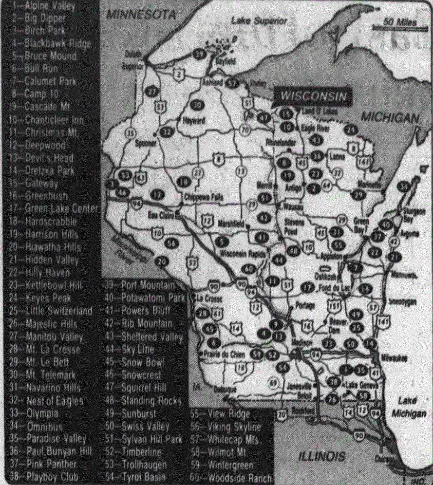
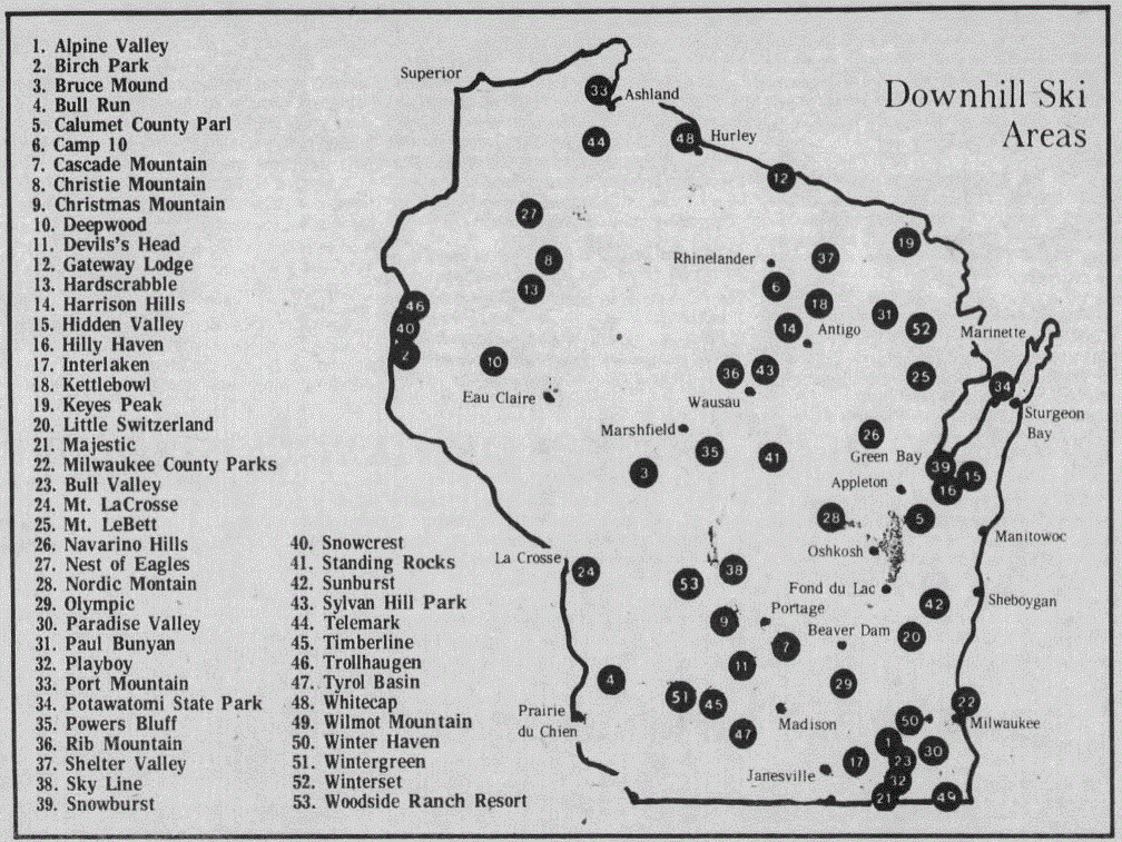
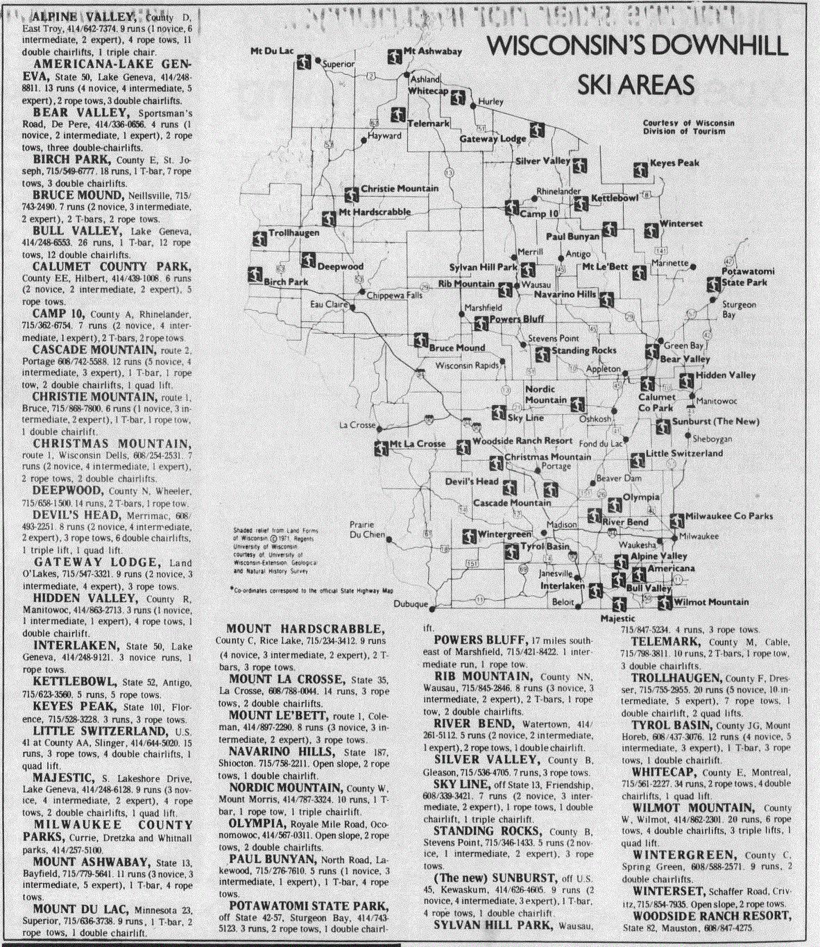
MAPS

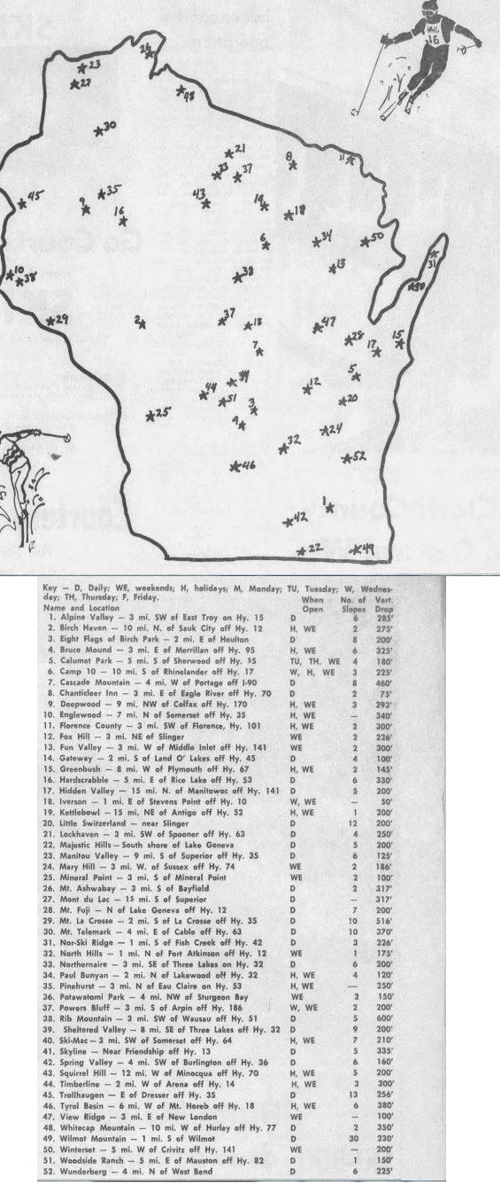
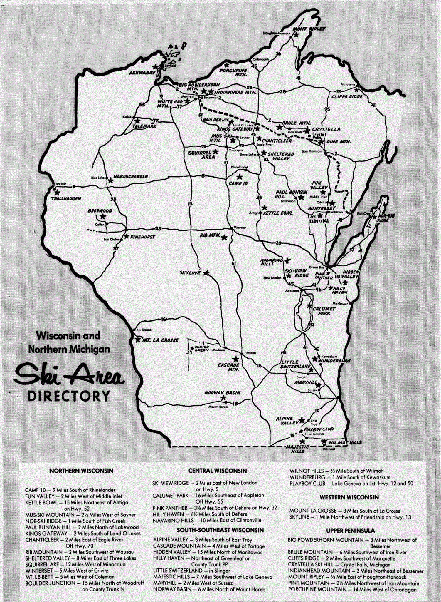
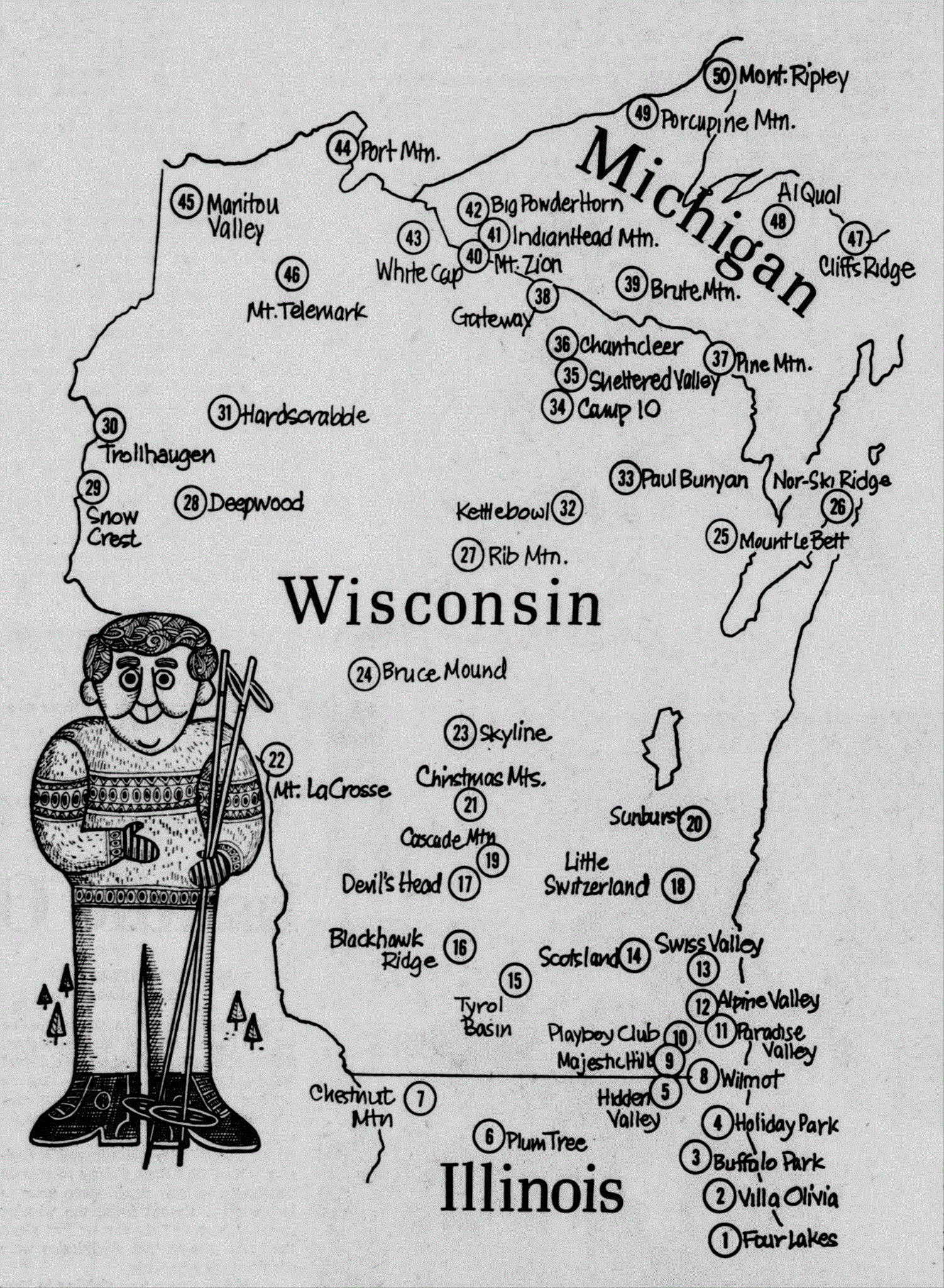
Lost
Wisconsin Ski Areas Facebook Page
- omissions noted

Minneapolis
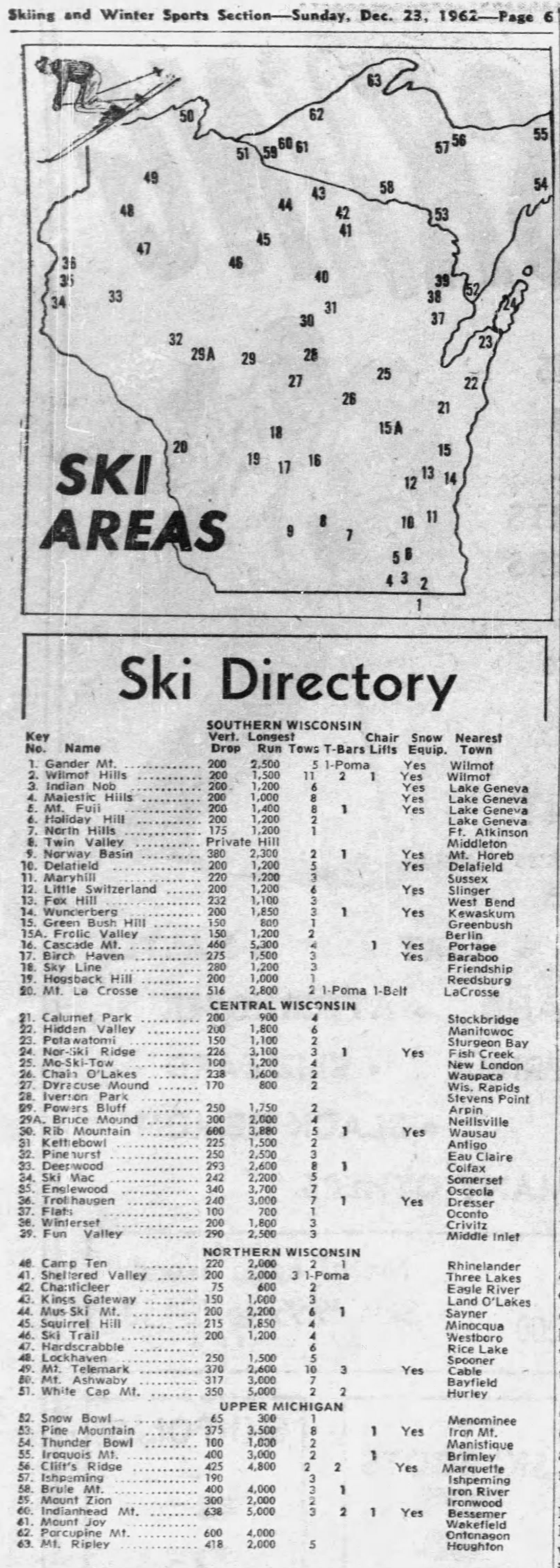
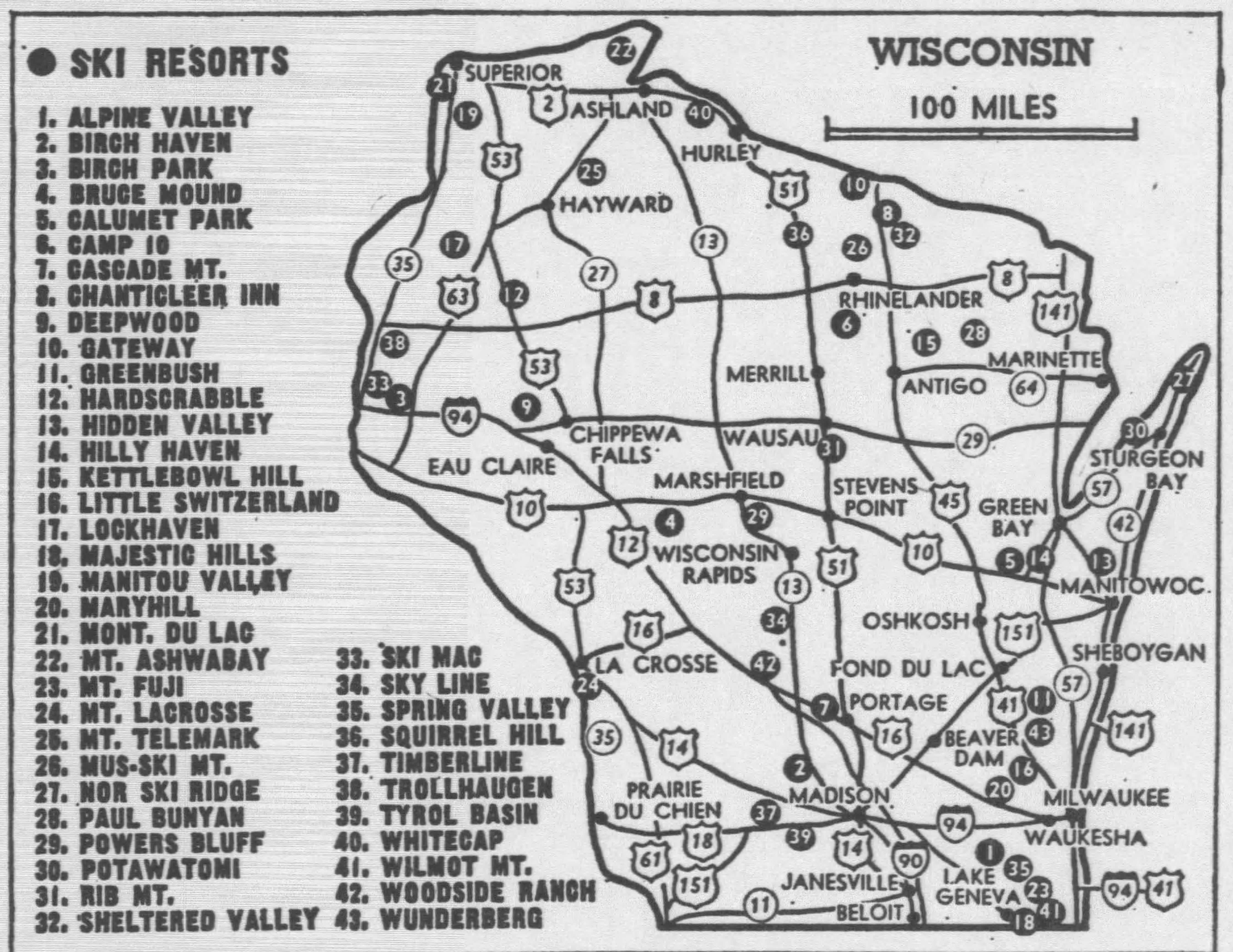
Tribune, Dec. 23, 1962, p. 53
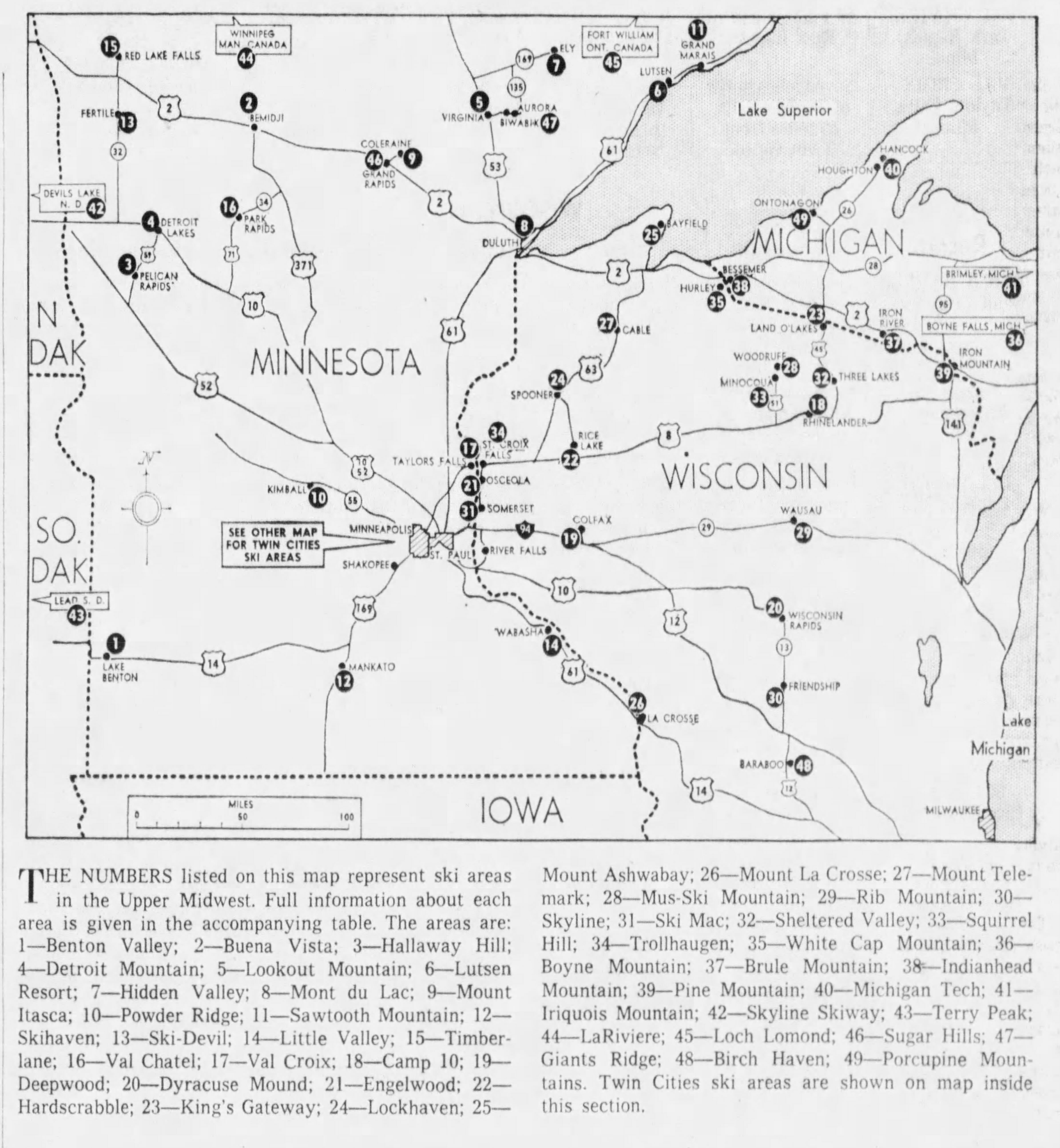
Wisconsin
State Journal (Madison, Wisconsin) · Sun, Dec 23,
1962
from Lost
Wisconsin Ski Areas Facebook Page
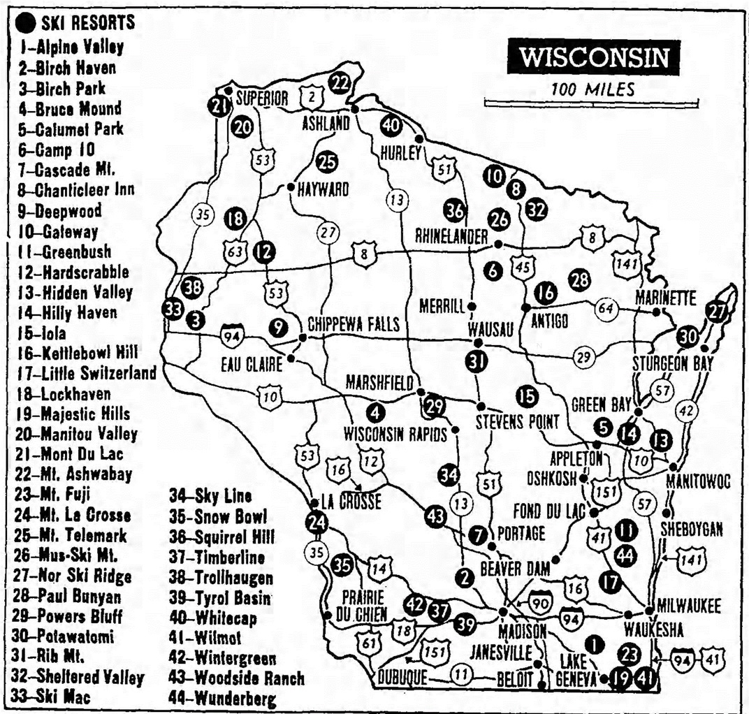
Mid-1960's
from Lost
Wisconsin Ski Areas Facebook Page
Chicago Tribune,
Dec. 8, 1967
Chicago Tribune,
Sunday, December 01
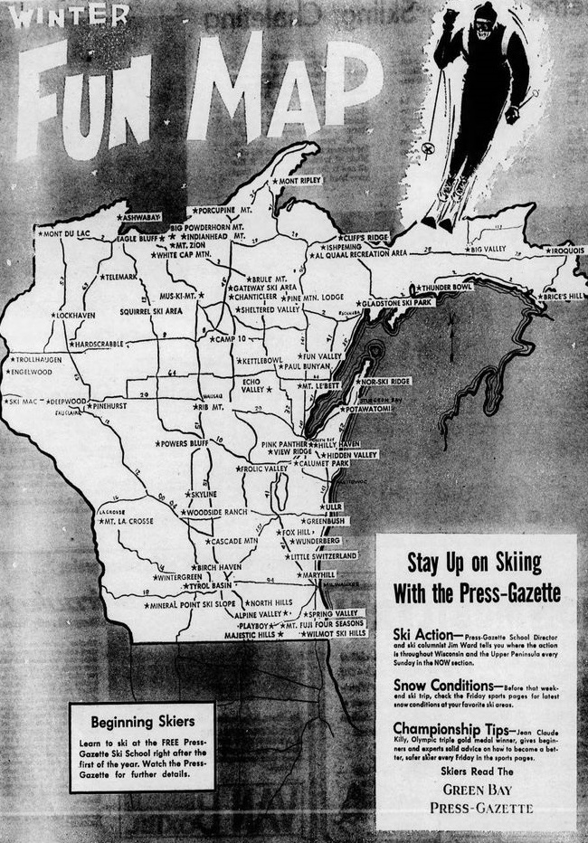
Green Bay Press
Gazette
Lost
Wisconsin Ski Areas Facebook Page
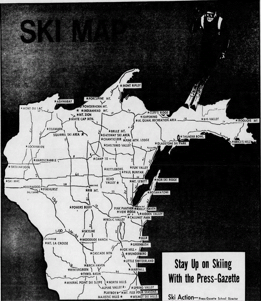
Green Bay Press
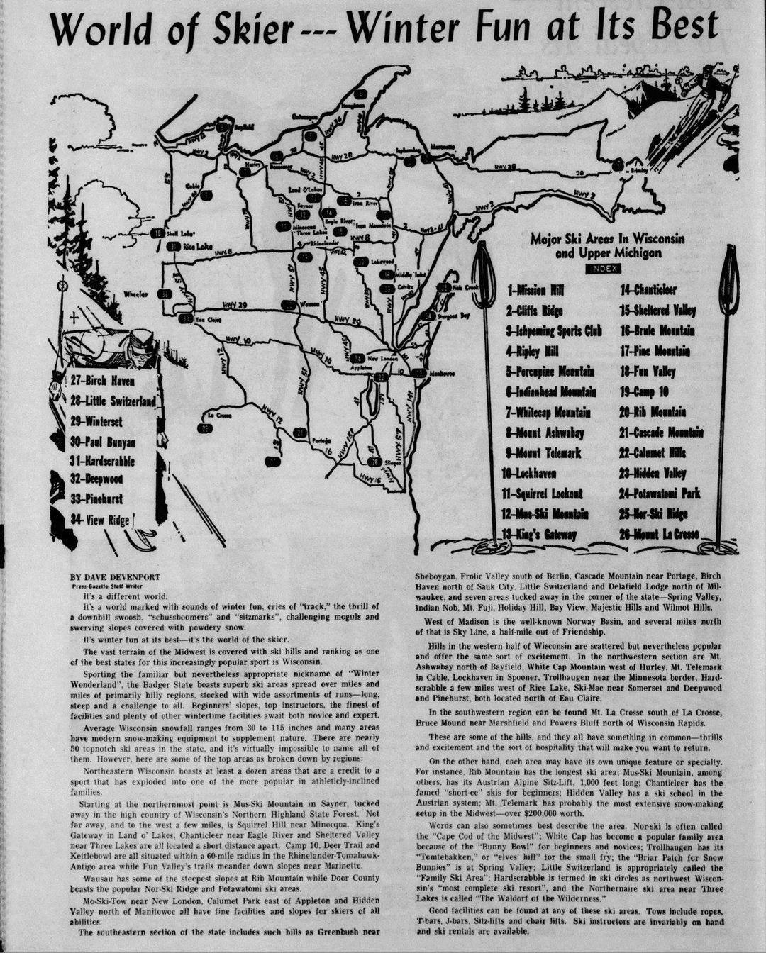
Gazette
Lost
Wisconsin Ski Areas Facebook Page
Green Bay
Press Gazette, Dec. 12, 1971

Wisconsin Rapids
Daily Tribune
Lost
Wisconsin Ski Areas Facebook Page
Lost
Wisconsin Ski Areas Facebook Page
Lost
Wisconsin Ski Areas Facebook Page
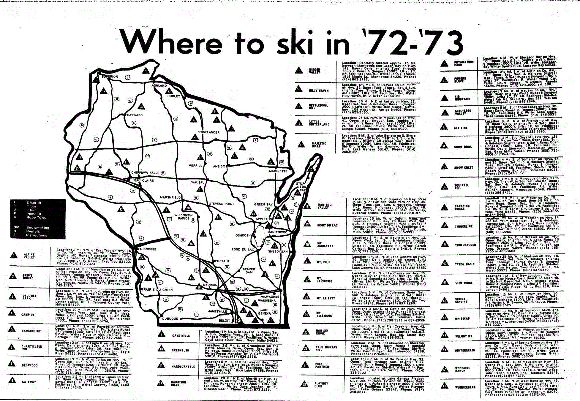
1973

(not all areas
listed)
See Lost
Wisconsin Ski Areas Facebook Page
for corrections
See
Lost
Wisconsin Ski Areas Facebook Page
(map corrections)
The
Post-Crescent (Appleton, Wisconsin) · Sat, Jan 10,
1981
The Post-Crescent (Appleton,
Wisconsin) · 15 Dec 1985 (Note: Bull Valley in Lake
Geneva was the former Mt.
Fuji.
Cross country skiing only - it did NOT have "1 T-bar, 12
rope tows, and 12 double chairlifts")
|