|
|
LOST
AREAS
Allen's
Thrill Hill
- Cologne, MN (Carver County) - 28
miles SW of Minneapolis - 9310 County Road 140, Cologne,
MN
- v: 150 ft.,
- upside
down (lodge at the
top)
- Google
Maps
/ Google
Earth
44.79960829618372, -93.75666082824594
- I
Like It Here by George Grim
- Minneapolis Tribune, Jan. 20, 1960, p. 14
- Ski
Areas - Allen's Thrill Hill
- Minneapolis Star, Dec. 14, 1965, p. 14
- Minnesota
Outdoor Recreation Plan, 1965
- p. 251
Alpenhorn*
(became Crystal
Hills)
Andersen's
Hill+
(became Ski Haven, still open as
Mt.
Kato)
Arctic
Park*
- also called Mt.
Sitzmark
Bamber
Hills (also called
Rochester Ski Hill)
Barkers
Alps (also called North
Star Tow)
- Bayport, MN - (Washington County)
southeast Minnesota - half mile southwest of Stillwater
State Penitentiary
- Google
Maps / Google
Earth
45.020158424926116, -92.79056484707569
- Midwest
Set for a Banner Year in Snow
- Chicago Tribune (Chicago, Illinois) · Sun, Dec 8,
1946
- Ski
Resorts Ready as Snow Piles Up
- Minneapolis Tribune, Jan. 6, 1952,
- Metro
areas have sprouted up, faded away,
Minneapolis Tribune Nov. 20, 1977
- Ski
Hall-of-Famer still medals at 84
- Shoreview Press
Battle
Creek Park
(Davis Bros. Tow)
Benton
Valley * see
Hole
in the Mountain County Park
Big
Ojibway *- see
Ojibway
Ski Bowl
Blaine
Ski Area^
Breezy
Point Estates
Buffalo
Valley Ski Area
- Buffalo, MN (Wright County) -
central Minnesota - 1730 Bolton Dr NW, Buffalo,
MN
- v: 240 ft. o: 1966 c: 1972, 7 rope
tows in 1966
- Google
Maps / Google
Earth
45.17553124458687, -93.91665690816872
- Pioneer
Park, Buffalo Valley, tell stories of two
dreams - Minneapolis
Tribune, Oct. 7, 1977
- Advertisement
- St. Cloud Times, Feb. 8, 1969
- Advertisement
- Minneapolis Tribune, Jan. 7, 1972
- Ski
Area Guide, SKIING
Magazine, Sept. 1969, pp. 162-164
- Ski
facilities, new, old and changed
(third column) - Minneapolis Star, Nov. 9, 1972 -
closed
- skimap.org
(0 maps)
Bush
Lake
- Bloomington, MN (Hennepin County)
- Twin Cities area
- Google
Maps / Google
Earth
44.85320416688552, -93.36473761612218
- Bush Lake is a ski jumping area,
but it also had dowhill skiing and races.
- Why
Minneapolis Skiers Are Tops
- The Minneapolis Star (Minneapolis, Minnesota) ·
Sun, Feb 1, 1942
- Expert
Gives Data on Nearby Ski Hills
- Star Tribune (Minneapolis, Minnesota) · Sun, Jan
8, 1950
- Upper
Midwest Ski Facilities Outlined
- Star Tribune (Minneapolis, Minnesota) · Sun, Jan
29, 1950 - "One 400 foot tow"
- North
Shore Skiing Improves With Snow
- Minneapolis Tribune, Jan. 28, 1951
- Bush
Lake Skiers in FIS Tryouts
- Minneapolis Tribune, Dec. 20, 1953
- The Bush Lake Ski Jump is about
1/2 mile North of Hyland
Hills Ski Area (still
open)
Cedar
Hills Ski Park
Comet
Skiways
- Snellman, MN (Becker County) - 19
miles east of Detroit Lakes on hwy 34 / Wolf Lake - 25 mi
. S.W. of Park Rapids [The American Ski Directory
1961 by William Pain (Author)]
- v: 185 ft., o:
1958-64?
- Google
Maps / Google
Earth (Snellman, MN)
46.80335220757042, -95.35233661309049
- Shell Lake Township Centennial
Book of 1997 - short history (Thank you to Jo Jo) -
page
104 / page
105
- Ballard
Residents and Dates Ski Tomorrow -
(From the Western
Mistic, March 4, 1955, p. 5,
State Teachers College, Moorhead Minnesota - now
Minnesota State at Moorhead)
- Finns
in Minnesota - By Arnold
Robert Alanen · 2012 , Google
Books
- Upper
Midwest Ski Areas,
Minneapolis Tribune, Dec. 7, 1958
- Ski
Areas of the Midwests,
Minneapolis Tribune, Dec. 17, 1961
- Skiers
Take to Chartered Busses -
Minneapolis Star, Dec, 20, 1963
- ON MAPS: 1955 (Comet Skyways)
1958, 1959, 1961, 1963, 1964. NOT ON: 1962, 1966 and
later maps.
Crestwood
Golf and Ski
Crystal
Hills (formerly
Alpenhorn)
- Paynesville, MN (Sterns County ) -
central Minnesota - hwy 55 (4), west bank of Crow River
north fork, where it flows under 55 between Koronis and
Rice lakes
- no skiing fall 1973 (not sure if
lifts actually ran) c:1977 ?
- Formerly called Alpenhorn
- Google
Maps / Google
Earth
45.33100687429801, -94.66818292621268
- Million
Dollar Resort Offers Dining and Dancing in
Style - Minneapolis
Tribune, July 8, 1973, p.2F
- picture
- Minneapolis Tribune, July 8, 1973, p.2F
- Ski
Resort Facilities Improved
- Minneapolis Tribune, Nov. 11, 1973, p. 1F
- advertisement
- St. Cloud times, May 2, 1974
Crystal,
MN Rope Tows
- Crystal, MN - Valley Place Park -
6822 32nd Ave. N.
- Google
Maps / Google
Earth
45.01566382415604, -93.36718313357937
- Email from Doug Holsten (Sisters,
Oregon): "
One more to bring to your attention... I have a younger
brother who says the City of Crystal (MN) operated a
double rope tow at one of their parks. My brother is 9
years younger that I am so guessing his memory is from
the early to mid 70s. "
- Email from John Elmhold, City of
Crystal recreation Department:
"My understanding is there were two tow ropes at Valley
Place Park. It is currently a very popular lighted
sliding/sledding hill that is operated by the City of
Crystal. The rope tow was likely used more for
sliding/sledding than for skiing, but has been gone a
long time. This park was once called Lions Valley Place
Park if that matters." - Crystal.Recreation@crystalmn.gov
Darwin
Winter Recreation Park
- Darwin / Dassel MN (Meeker County)
South Central Minnesota
- Google
Maps / Google
Earth
45.09393830016789, -94.37771733834762
- From Midwest Lost Ski Areas
Facebook Page - Old
ski hill between Darwin and Dassel Minnesota. We fly our
paragliders off it now.
- from Meeker County Museum at the
GAR Hall
- Hi Mark,
We weren't able to find any
definite dates, but I did put a request for memories
from a local Facebook group and was able to gather a
few details from their comments. The rope tow was in
operation sometime during the 1970s-80s. It was shut
down due to liability concerns. One person remembered
watching more than one person shoot across the highway
on their toboggan. You would lay on your tube or sled
and grab on to the rope (often with a good jerk of the
shoulders) to be towed up the hill, hoping you don't
lose your sled on the way up. One gentleman commented
that he went through a pair of gloves each
year.
Sorry we couldn't be of more
help, but it looks like the people enjoyed
reminiscing! If we get any more details, we will be
sure to pass them along if you are interested.
Danelle Erickson
Davis
Bros.Tow*- see
Battle
Creek Park
Eagle
Mountain Ski Area
Edina
Ski Tow
- Edina, MN - Twin Cities area
(Hennepin County) - "near hwy 169 and (old) county road
18"; on 169 [hwy 169 realigned in 1988]; hill
faces north; 5 min from Edina Country Club; on the George
Vessey Farm, 6501 Hwy. 169 West, Hopkins Rt 1 (in
1951)
- v: 100 ft, o: 1951, last mention
Jan.1953
- Edina
Ski Tow Open - Star Tribune
(Minneapolis, Minnesota) · Tue, Dec 25,
1951
- Google
Maps / Google
Earth
44.899208308460295, -93.39164220343932
Walnut Ridge Park
Please email - mark@mwlsap.org - if you know a more
precise location.
- Edina City Council Minutes -
Edina
Docs Document Archive
(Thank you to the Edina Historical Society)
- Scene
in Edina - Minneapolis
Tribune, Jan, 6, 1952 (nice pictures)
- Ski
Resorts Ready as Snow Piles up
- Minneapolis Tribune, Jan. 6, 1952, p. 27
- Skiing
Pros Have Stimulated Sport
- Star Tribune (Minneapolis, Minnesota) · Sun, Dec
28, 1952
- Ski
Reports - Minneapolis
Tribune, Jan. 1, 1953
Egan's
Resort / Egan's Hidden Valley Ski
Tow*
(see Hidden
Valley)
Eko
Backen
Finland
Air Base
- Finland, MN (Lake County) -
northeast Minnesota - 2.8 miles north of Finland,
MN
- v: 190 ft. o: 1950
- Google
Maps / Google
Earth
47.45385365963821, -91.23748584915985
- skimap.org
(0 maps)
Fond
du Lac Winter Sports Center*
- see Ojibway
Ski Bowl
Fred
Sims Park * - see
Hew Hope Rope
Tow
French
Rapids
- Brainerd, MN (Crow Wing County) -
central Minnesota
- v: 120 ft
- Google
Maps / Google
Earth
46.40280936250696, -94.15330308484818
- Snow
Carnival at Brainard to Begin with
Ball - St. Cloud Time, Feb.
4, 1955, p. 8
- Skiing
Your Holiday Sport? -
Minneapolis Star, Dec, 24, 1966, p. 14
- Minnesota
Outdoor Recreation Plan, 1965
- p. 251
- Ski
Area Guide, SKIING
Magazine, Sept. 1969, pp. 162-164
Glenhaven
Gokey's
Hlil + (still open
as Buck
Hill)
- Burnsville, MN (Dakota County) -
near Twin Cities
- o: 1940
- FIRST
IN STATE along with Moon
Valley
- Ski
Run Lift Is Being Built -
The Minneapolis Star (Minneapolis, Minnesota) · Mon,
Nov 22, 1937
- Ski
Tow Ends Climb Back
(picture) - The Minneapolis Journal Minneapolis,
Minnesota · Monday, January 17, 1938
- Ski
Trails - The Minneapolis
Star (Minneapolis, Minnesota) · Sun, Jan 14, 1940
(Gokey's Hill)
Golden
Gate To Fun
Hallaway
Hill Ski Area
(Hollaway)
- Pelican Rapids, MN - (Otter Tail
County) - west central, Minnesota - 5 miles east of
Pelican Rapids, now Maplewood
State Park, on South Lake
Lida
- v: 200 ft
- Google
Maps / Google
Earth
46.548708673639986, -95.98578503997342
1953
Plat Map - courtesy of the
Otter Tail County Historical Society
- Map
of Halloway Hill Trail in Maplewood State
Park
- Hallaway
Ski Hill Opens This Week - 50 Years
ago - Pelican Rapids Press,
December 8, 2021 - scroll down, free subscription may be
needed
- Maplewood’s
Hallaway Hill was a true community collaboration in the
1950s-60s - Pelican Rapids
Press, February 10, 2021, - free subscription may be
needed
- With
Detroit Mountain, Hallaway Hill–and
Rollag’s Royal Oak–the lakes area was
formidable ski mecca … by prairie
standards - Pelican Rapids
Press, March 10, 2021 - free subscription may be
needed
- Halloway
Hill -
Outdoorproject.com
- Ski
Report - Minneapolis Star,
Dec, 31, 1953, p. 11
- skiinghistory.org
- Northland Executive and Minnesota Ski Area Founder
Dies
- Two
City Portias, Herou and Scott, Like Skiing,
Too - Minneapolis Tribune,
Dec. 13, 1953
- Minnesota
Outdoor Recreation Plan, 1965
- p. 251
- Halloway
Ski Hill Sold, Improvements Are
Planned - The Daily Journal
(Fergus Falls, Minnesota) · Wed, Dec 6,
1967
- skimap.org
Hidden
Valley
Hidden
Valley (another one - also
called Egan's Resort and Egan's Hidden Valley Ski
Tow)
- Savage, MN ( Scott County); - near
Twin Cities
- now Hidden Valley Park, Savage,
MN
- o: 1964, two rope tow
- Google
Maps / Google
Earth
44.762681062867465, -93.3428719688989
- Ad
- Burnsville Historical Society Archives
- Ski
Trails - Needed Snow Expected at
Aspen - Minneapolis
Tribune, Jan. 4, 1948, p. 54 (near bottom of second
column)
- Ski
Reports - Minneapolis
Tribune, Jan. 1, 1953
- Ski
Facilities Accellerate at Rapid
Rate, Minneapolis Tribune,
Nov. 15, 1964
- Ski
Areas - Hidden Valley -
Minneapolis Tribune, Dec. 23, 1965
- History:
New Savage resident discovers old history of his
backyard -
swnewsmedia.com
- What
is the history of the fireplace in Hidden Valley Park?
-
cityofsavage.com
Hole
in the Mountain County Park
- also called Benton Valley and Lake Benton
Valley
- Lake Benton, MN (Lincoln County) -
southwest Minnesota
- could be the same as
Benton
Valley
- v: 175 (134) ft. v: 150 ft,. o:
1950,- at lease 1981,
- operator of Benton Valley: Carl G.
Westli
- In 1978 (Skalka):
3 rope tows
- Google
Maps / Google
Earth
44.262440533299994, -96.30503021293637
- Brief
History - from Lake Benton
Chanber of Commerce, 125 year history book
- Ski
Season Set At Lake Benton -
Argus Leader Sioux Falls, SD), Dec. 27, 1953
- Ski
Report - Benton Valley -
Minneapolis Star, Dec, 31, 1953
- Skiing
Your Holiday Sport? -
Minneapolis Star, Dec, 24, 1966, p. 14 (Both Pipestone
and Benton Valley are listed in this article and both are
listed as "closed".
- Ski
slopes on the prairie -
Argus-Leader (Sioux Falls, South Dakota) · Sun, Dec
13, 1981
- Minnesota
Outdoor Recreation Plan, 1965
- p. 251 (.pdf p. 260)
- Two
City Portias, Herou and Scott, Like Skiing,
Too - Minneapolis Tribune,
Dec. 13, 1953
- Group
bringing back tubing – in a year with no
snow
- master
plan - see page 35 for map
showing sledding hill
- skibum.com
- scroll down to near bottom
- skimap.org
(0 maps - tow has been removed)
Inver
Hills Ski Hill (previously
called NorSki)
Keller
Golf Course Rope Tow
- Maplewood, MN, Ramsay County -
Twin Cities area
- late 1960s to early
1970s
- Google
Maps / Google
Earth
45.006134855651524, -93.05691460533164
- Ski
The Midwest Facebook Group,
Twin Cities Ski Areas - See comments from Robert
Palmquist
- Skiers
and Snowboarders of the Midwest Facebook
Group - see comment by
Robert Palmquist
- "The Keller Golf Course in
Maplewood, MN (suburb of St. Paul), which is still
operating as a golf course, used to have a small ski
area next to its clubhouse. It was just a single tow
rope, with lights for skiing in the evenings. I used
to go there a lot as a kid, but I can't find a single
picture of it or barely any mention of it on the
Internet. It was definitely open in the late 1960s, I
do not know when they shut it down, I'm guessing in
the early 70s. Here's a link to the golf course:
https://www.ramseycounty.us/residents/parks-recreation/golf/golf-courses/keller-golf-course"
- emails sent to
info@maplewoodmuseum.org and
info@maplewoodhistoricalsociety.org on
4/29/24
Kenwood
( see Ski
Kenwood)
Knob
Hill Ski Club (Nob Hill)
- Hastings, MN
- If you have any information on
where Knob Hill was located please contact me at:
mark@mwlsap.org
- o: 1940
- Ski
Trails by Lloyd Borg - The
Minneapolis Star (Minneapolis, Minnesota) · Sun, Dec
15, 1940
- Why
Minneapolis Skiers Are Tops
- The Minneapolis Star (Minneapolis, Minnesota) ·
Sun, Feb 1, 1942 - "Near Hastings the Knob Hill club has
a chalet and tow".
- Excellent
Race Facilities in Twin Cities
Area - Star Tribune
(Minneapolis, Minnesota) · Sun, Dec 15, 1946
- "The Nob Hill Ski Club will
operate again this year. With a small tow and a small
shack this club necessarily has a small membership,
but at present a few vacancies are open."
- Coleman
to Head Knob Hill Ski Club
- Star Tribune (Minneapolis, Minnesota) · Sat, Apr
22, 1950
- Mas,
Pas, and Juniors Have 'Ups and Downs' on Ski
Slopes - Star Tribune
(Minneapolis, Minnesota) · Fri, Dec 19,
1952
Lake
Benton Valley*
- see Hole
in the Wall county Park
Lester-Amity
Park Ski and Jumping Area
- Duluth, MN (St. Louis County)
northeast Minnesota - 2940, Seven Bridges Rd,
Duluth
- v: 62 ft.
- 1 rope tow
- Google
Maps / Google
Earth
46.855314045405954, -92.01268887825745
- skimap.org
(0 maps) - this is the only reference I can find stating
that there was a rope tow, but this reference has been
removed.
Little
Squaw Valley
Lone
Lake Ski Club
- Minnetonka, MN (Henepin County) -
near Twin Cities
- Hopkins, MN Shady Oaks Rd., south
of Shady Oak Lake
- o: 1936 (probably no tow)
rope
tow 1939
- Google
Maps / Google
Earth
44.900886676802344, -93.42760477571105
- Twin
Cities Winter Sportsters Get Set for Cold Weather
Fun - Star Tribune
(Minneapolis, Minnesota) · Sun, Nov 19,
1939
- Why
Minneapolis Skiers Are Tops
- The Minneapolis Star (Minneapolis, Minnesota) ·
Sun, Feb 1, 1942
- Private
Lone Lake Ski Club Winding Up Its Best
Season - The Minneapolis
Star, March 16, 1965
- skimap.org
(0 maps)
Lookout
Mountain (Lookout
Lodge, Minnesota's Lookout Mountain)
- Virginia, MN (St. Louis County) -
northeast Minnesota
- v: 302 ft., o: 1958, c: 1970, 1
double chair - First
chairlift in
Minnesota
- Google
Maps / Google
Earth
47.57774404504111, -92.54371886993975
- Vintage Video: LookoutMt..m4v
- YouTube (12:22) - a lot of vintage video with audio of
the ski area's history
- Picture
- Minnesota Governor Elmer Anderson at Lookout
Mountain
- Guide
to Ski Areas - Sports
Illustrated, Dec. 1958
- Homemade
Mountains - Sports
illustrated, Dec. 1, 1958
- Guide
to Ski Areas - Sports
Illustrated, Dec. 1, 1958
- New
Ski Facilities - Sports
Illustrated, Nov. 23, 1959
- New
Ski Facilities - Sports
Illustrated, Nov. 21, 1960
- Minnesota
Outdoor Recreation Plan, 1965
- p. 252
- Final Schuss Spells Death of
12-year old Ski Area - Star Tribune (Minneapolis,
Minnesota) · Sun, Oct 11, 1970 - part
1 / part
2
- skimap.org
Marthaler
Ski Area
Moon
Valley Ski Area
- Shakopee / Chaska, MN (Dakota
County) - near the Twin Cities - 100 Flying Cloud Dr,
Chaska, MN
- v: 200 ft., o: 1938,
south
facing
- FIRST
IN STATE along with Gokey's
(now Buck) Hill)
- Google
Maps / Google
Earth
44.81777443225282, -93.52347366536176
- Ski
Run Lift Is Being Built -
The Minneapolis Star, Nov 22, 1937
- Ski
Trails - The Minneapolis
Journal (Minneapolis, Minnesota) · Sun, Dec 4,
1938
- Midwest
Set for a Banner Year in Snow
- Chicago Tribune (Chicago, Illinois) · Sun, Dec 8,
1946
- 1951-52
Directory Winter Sports
Playgrounds, Chicago and
North Western Railroad
- Ski
Slope Snow Conditions Report
- Minneapolis Tribune, Jan. 2, 1967
- Moon
Valley Aces Score Sweep -
Minneapolis Star, Jan. 13, 1941
- The
Skis the Limit (good
pictures) - Minneapolis Tribune, Jan. 27,
1946
- picture
- https://forums.alpinesnowboarder.com/topic/51394-defunct-mn-ski-resorts/
- MN
Sec. of State - Business Registration -
bizapedia
- brief
mention in personal story
- Apres-Ski
photo for sale - vintageskiworld.com
- Minnesota
Outdoor Recreation Plan, 1965
- p. 251
Mt.
Carmel *- See
Saint John's University
Mt.
Florida
- Spicer / Willmar, MN - (936 S,
First St.) (Kandiyohi County) - central Minnesota - 13
mi. N of Wilmar, 5 mi. W of Spicer
- Dickerson's Resort, 13194 2nd
Street N.E., Spicer, MN fornerly called Shady Rest Beach
Resort and Lake Florida Resort - pictures
- 1958-59, 1959-60
- on 1958
and 1962
maps
- Highest hill in area:
Google
Maps / Google
Earth
45.25569532780207, -95.0359808636332
Please email - mark@mwlsap.org - if you know a more
precise location.
- Location of resort on Lake:
Google
Maps / Google
Earth
45.25211772605166, -95.04016986545808
- The American Ski Directory,
by William Pain, Permabook, 1961
- These are the only references that
I could find:
- Bob Larson, Kandiyohi County
Historical Society:
"I can't find any articles or pictures of Mt. Florida. I
did talk to a family member and it was a Downhill Ski and
Toboggan Hill on the NE side of Lake Florida 1958-1960.
They had rope lift and a warming house. Because of lack
of snow in those years it never got going. Here are
pictures of where it would have been. I hope you can use
this; it is all I could Find.."
Pictures 1
2
Mt.
Frontenac
- Frontenac, MN (near Red Wing,
Goodhue County) - southeast Minnesota
- v: 420 ft. c:
2003
- In 1978 (Skalka):
3 rope tows, 2 T-bars, 1 chairlift
- Google
Maps / Google
Earth
44.51293298181389, -92.38391985240614
- ??? Mankato,
Red Wing Projects Swell List of Ski
Areas - Star Tribune
(Minneapolis, Minnesota) · Sun, Dec 15,
1957
- SKI
Magazine, Jan. 1975
(link)
- SKI
Magazine, Jan. 2002
(link)
- Skiers and Snowboarders of the
Midwest - Facebook Group 1
2
- skibum.net
- skimap.org
Mt.
Normandale+
- still open as Hyland
Hills
Mt.
Notch
- same location as the Tyrol
Ski Tow
(1949)
- Avon, MN (Sterns County) - 2 mi. S
of Avon on hwy 50, turn on Schuman Lake Rd., N of Schuman
Lake Rd.
- o: 1989, c. 1989
- Google
Maps / Google
Earth ???
45.58268651659414, -94.45001853405277
Please email - mark@mwlsap.org - if you know a more
precise location.
- 16582 Schuman Lake Rd (from
brochure)
Google
Maps / Google
Earth
45.574320034874475, -94.45150895059321
- Mt.
Notch May Open This Fall -
St. Cloud Times (Saint Cloud, Minnesota) · Tue, Aug
9, 1988
- Mt.
Notch has room to grow -
St. Cloud Times (Saint Cloud, Minnesota) · Sun, Jan
22, 1989
- advertisement
- St. Cloud Times (Saint Cloud, Minnesota) · Sun,
Jan 22, 1989
- Brochure
with trail map
- Slopes
- St. Cloud Times (Saint
Cloud, Minnesota) · Sun, Dec 31, 1989
- Stearns
County Spotlight: Mt. Notch Ski
Area; Avon, Minnesota -
Stearns history Museum Facebook Page
- Mt.
Notch Opens Ski Runs -
mentions that the location had a tow rope "about forty
years ago . . . for about two years" - Stearns History
Museum - this was most likely the Tyrol
Ski Tow
- skimap.org
Mt.
Rockwood
- Silver Bay, MN (Lake County) -
northeast Minnesota
- v: 430 ft. o: 1966, c:
1972
- Google
Maps / Google
Earth
47.3172718221796, -91.26232620983713
- Google
Earth Satellite View
- Skiers
and Snowboarders of the Midwest Facebook
Group
- Ski
Slope Snow Conditions Report
- Minneapolis Tribune, Jan. 2, 1967
- Ski
Area Guide, MN, SKIING
Magazine, Sept. 1969, pp. 162-164 (source-google
books)
- Sale
Notice - Minneapolis
Tribune, Aug. 6, 1972
- skimap.org
(0 maps)
Mt.
Rushford*
(see Rushford)
Mt.
Silver (silver
Creek?)(may be the same as Two
Harbors)
- Two Harbors, MN (Lake County) -
northeast Minnesota - 4 miles north of Two Harbors on Hwy
61 near the Silver Creek tunnel., on Silver Fox
Ln
- Google
Maps / Google
Earth
47.06438654780687, -91.61279636416776
Thank you to Doris Ressl for a more precise
location
- recent
photo - thank you to Doris
Ressl
- North
Shore Skiing Improves With Snow
- Minneapolis Tribune, Jan. 28, 1951
- Twin
Cities Ski Feud on Today
-Silver Creek - 4 mi. N of Two Harbors Star Tribune
(Minneapolis, Minnesota) · Sun, Jan 7,
1951
- Ski
Reports - The Minneapolis
Star (Minneapolis, Minnesota) · Thu, Feb 28,
1952
- Ski
Resorts Ready as Snow Piles up
- Minneapolis Tribune, Jan. 6, 1952, p. 27 (see last
paragraph)
Mt.
Sitzmark - also called
Arctic Park
- Shoreview, MN (Ramsay County) -
near Twin Cities - east of Victoria St. and south of
Gramsie Rd
- v: 125 ft.
- Google
Maps / Google
Earth
45.061102786027476, -93.12362072221859
- Ski
Slope Snow Conditions Report
- Minneapolis Tribune, Jan. 2, 1967, p.25
- Former
St. Paul Ski Jumper Solves Snow-making
Costs - Minneapolis
Tribune, Dec. 28, 1967, p. 38
- Ski
Area Guide, SKIING
Magazine, Sept. 1969, pp. 162-164
- Operators
Describe Ski Facilities -
Minneapolis Tribune, Nov. 17, 1968 - Arctic
Park
New
Brighton Rope Tow*
(probably same as TCAAP)
- New Brighton, MN (Ramsey County,
north of New Brighton) - near the Twin Cities
- Google Maps / Google Earth ???
Please email - mark@mwlsap.org - if you know a more
precise location.
- Metro
ski areas have sprouted up, melted
away
- Minneapolis Tribune Nov. 20, 1977, p. 117
New
Hope Rope Tow
- New Hope, MN - NW of Minneapolis -
Fred Sims Park, 4350 Nevada Ave N
- c: 1975
- Google
Maps / Google
Earth
45.03554825457216, -93.37168349307002
- Email from Doug Holsten from
Sisters, Oregon. Thank you.
- " I enjoyed perusing your
Minnesota lost ski areas web page. I did not see one
very small ski hill on your list that I will bring to
your attention. The City of New Hope, MN operated a
rope tow at a city park in the late 1960s. I do not
know when skiing started and ended at the park but I
know it was active in about the 1966-1968 time frame
(I was a young teenager). While I am not absolutely
sure, I think the rope tow was setup at Simms Park (at
intersection of 45th Ave N and Nevada Ave N). The
vertical on the hill was likely less than 50 ft so
perhaps this operation was just too small to make your
list."
- Email from Susan Rader, City of
New Hope , Director of Parks and Recreation
- Hi Mark,
From what I can find, yes, Fred
Sims Park did have a rope tow for several years. I
can’t tell you a specific start date, but it
would have been in the mid to late 1960’s. I also
found that it was discontinued in 1975 due to budget
cuts.
Nordmarken
Ski Area
Norski
Hill*
(later became Inver
Hills)
North
Oaks
(also North Oakes)
- N of St. Paul (Ramsay
County)
- Google
Maps / Google
Earth
45.08630508931592, -93.08804799062293
Hill
Farm - Star Tribune
(Minneapolis, Minnesota) · Sun, Mar 12,
1950
- Hill
Farm to be Developed as Model
Village - The Minneapolis
Star (Minneapolis, Minnesota) · Mon, Jan 16,
1950
- Skiing
Best in Several Seasons -
Star Tribune (Minneapolis, Minnesota) · 10 Dec
1950
- State
Ski Aces Pauly, Oakvik Train in
West - Star Tribune
(Minneapolis, Minnesota) · Sun, Dec 17,
1950
- Sun
Valley Architect' to Develop Hill
Farm - The Minneapolis Star
(Minneapolis, Minnesota) · Mon, Feb 13,
1950
North
Star Tow*
- see Barker's
Alps
Ojibway
Ski Bowl - Also called:
Big Ojibway Mountain, Fond Du Lac Ojibway Bowl, Fond du Lac
Winter Sports Center
Old
Smokey Hill Ski Park
(Smoky)
Pine
Bend Ski Area
- Hastings, MN (Dakota County) -
South St. Paul / Rosemount, MN
- v: 258 ft c: 1972
- In 1958: 4 rope tows
- Google
Maps / Google
Earth
44.76530444851543, -93.02055617609334
- Pine
Bend - The Minneapolis Star
(Minneapolis, Minnesota) · Tue, Dec 14,
1965
- Advertisement
- Minneapolis Tribune, Nov. 15, 1970
- Skiing
Takes Dullness Out Of Sundays,
- The Minneapolis Star (Minneapolis, Minnesota) ·
Tue, Jan 26, 1965
- Guide
to Ski Areas - Sports
Illustrated, Dec. 1958
- Minnesota
Outdoor Recreation Plan, 1965
- p. 251
- skimap.org
(0 maps)
Pine
Valley
Pipestone*
(may be Hole
in the Mountain / Benton Valley)
Potter
Ridge *
???
- Kimball, MN - central
Minnesota
- v: 250 ft.
- Ski
Area Guide, SKIING
Magazine, Sept. 1969, pp. 162-164 This is the only
reference I could find. Probably did not exist. May be
confused with Powder
Ridge, Kimball, which is
stlil open.
Prior
Lake Ski Area
- Prior Lake, MN (Scott
County)
- o: 1967
- Google
Maps / Google
Earth ???
44.72864101813653, -93.4330808520157
location of town of Prior Lake
Please email - mark@mwlsap.org - if you know a more
precise location.
Email sent to City of Prior Lake and Scott County
Historical Society 10/30/23
- Suburban
Neighbors - Ribbon Cutting
Opened Prior Lake Ski Area - Minneapolis Star, Jan. 31,
1967 (Note: this is the only news article that I could
find.)
Quadna
Rochester
Ski Hill*
- see Bamber
Hills
Rock
Hill*
- see University
of Minnesota Duluth
Royal
Oak
Rushford
(Mt. Rushford)
Saint
John's University (Mt.
Carmel)
Saint
Mary's College
Sawtooth
Mountains Ski Area
Shingobee
Ski Area
- Walker, MN (5 miles southwest -
Cass County) - north central Minnesota - Shingobee
Recreation Area
- v: 150 ft. c: 1982
- Google
Maps / Google
Earth
47.03706869162941, -94.64402828673963
- Ski
Trails by Lloyd Borg - The
Minneapolis Star (Minneapolis, Minnesota) · Sun, Dec
15, 1940 ·
- Midwest
Set for a Banner Year in Snow
- Chicago Tribune (Chicago, Illinois) · Sun, Dec 8,
1946
- A
Moment in Time: Walker's Shingobee
Hills
- Midwest
Ski Areas, Minneapolis
Tribune, Dec. 7, 1958
- Minnesota
Outdoor Recreation Plan, 1965
- p. 251
Silver
Slopes
- Winona / Minnesota City, MN
(Winona County) - hwy 61, 3 mi. NW of Minnesota City, 9
mi NW of Winona, 1/4 mi off hwy 61
- o: 1947, still open in
1952
- ski jump added in 1948
- Google
Maps / Google
Earth ???
44.12978895017303, -91.78938412806193 ???
Please email - mark@mwlsap.org - if you know a more
precise location.
- Work
on Ski Trails by Minnesota City Begun by Chicagoans
- The Winona Daily News
(Winona, Minnesota) · Fri, Nov 8, 1946
- Silver
Slopes Ski Lodge, Area's Newest Fun Resort,
Opens - The Winona
Republican-Herald (Winona, Minnesota) · Mon, Feb 3,
1947 (pictures)
- Silver
Slopes Lodge Offers Free Lessons
- The Winona Republican-Herald (Winona, Minnesota) ·
Mon, Mar 12, 1951
- Silver
Slopes Ski Lodge Opens for Season -
The Winona Daily News (Winona, Minnesota) · Sat, Dec
6, 1947
- Ski
Improvements at Silver Slopes
- The Winona Daily News (Winona, Minnesota) · Wed,
Dec 1, 1948
- Voice
of the Outdoors - The
Winona Daily News (Winona, Minnesota) · Wed, Jan 23,
1952 (picture)
Singing
Hills
- Preston, MN (Fillmore County) -
southeast Minnesota - off of highway 52 within the
village limits, on the Root River
- v: 270 or 340 ft. (160 ft.) o:
1970 c: 1975
- Google
Maps / Google
Earth???
43.67421007734853, -92.0833791330755
(Town of Preston)
- Weatherman
holds key for Preston ski area
- The Winona Daily News (Winona, Minnesota) · Sun,
Dec 12, 1971
- Singing
Hills - The Minneapolis
Star (Minneapolis, Minnesota) · Mon, Nov 15,
1971
- Rock
festival peaceful - The
Winona Daily News (Winona, Minnesota) · Sun, Oct 22,
1972
- Ski
areas within weekend driving
- Minneapolis Star, Nov. 10,1972
- SKI
AREAS: New Additions are Listed
- Star Tribune (Minneapolis, Minnesota) · Sun, Nov
16, 1975
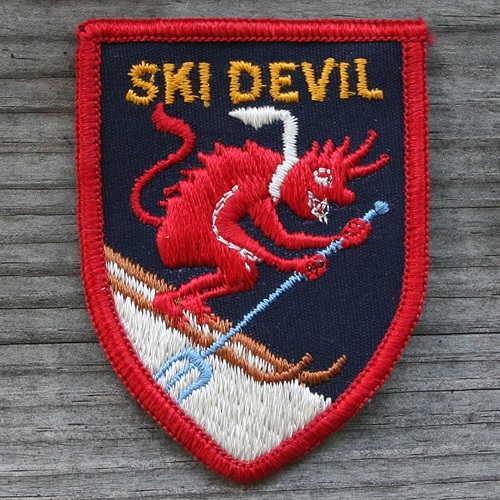
Ski
Devil
- Fertile, MN (Polk County) -
northwest Minnesota
- v: 150 ft o: 1961
- Google
Maps / Google
Earth
47.52402382559625, -96.2918849841037
- Community
Effort - Star Tribune
(Minneapolis, Minnesota) · Sun, Mar 6,
1960
- Ski
Report - Star Tribune
(Minneapolis, Minnesota) · Fri, Dec 29, 1961 (NOT in
1960 Ski
Report)
- See #3 on 1964
Minneapolis Tribune map
- Fertile
MN Facebook Comment
- Alf
Rognald Eide, initial investor in Ski Devil,
obituary
- Ski
Devil Patch
- Minnesota
Outdoor Recreation Plan, 1965
- p. 252 ERROR - listed as Rock County
- skimap.org
(0 maps)
Ski
Haven+
- became Mount
Kato in 1977 - still
open
Ski
Kenwood
- Duluth, MN - northeastern
Minnesota - near College of St Scholastica - off Kenwood
Ave, near where Partridge Street and the surrounding
apartments off Kenwood Avenue now sit.
- o: 1954
by George Hovland
- first ski area in
Duluth
- on 1955
map
- Google
Maps / Google
Earth
46.81052250651552, -92.10148675526277
- Nordic
Legend: George Hovland -
SkinnySki.com
- Duluth
athlete, 94, lived to ski and help promote the
sport - Star Tribune
(Minneapolis, Minnesota) · Tue, May 18,
2021
- George
Hovland, who fostered skiing in Duluth, dies at
94, - Duluth News Tribune,
May 10, 2021
Ski-Tonka
Skidahlen
- Pelican Rapids, MN (Otter Tail
County) - In what is now Maplewood State Park- west
central Minnesota
- v: 186 ft
- Google
Maps / Google
Earth ???
(Maplewood State Park)
46.515740796570945, -95.95133621436293
Please email - mark@mwlsap.org - if you know a more
precise location.
From Kathy Evavold of the Otter Tail County Historical
Society:
- In materials I looked at today,
I have not been able to find the location of Ski
Dahlen on any maps. It may be described in 1956 as,
“a hill developed by Monson a short distance west
of the hill [,] facing Lake Lida.”
This same 1956 newspaper article
says that Hallaway Ski Hill Inc. became part of a new
corporation known as Hallaway-Ski Dahlen Inc.
For a time today I had thought
it was located further south, on land owned by Philip
Monson, but I am still not certain. In a newspaper
article from 1967, it is mentioned as part of an
article regarding the proposed development of
“Maple Mountain” which appears to have never
materialized. That article says, “the area will
include what was Ski-dahlen, with three hills to
provide runs up to 2400 feet. The vertical drop on the
hills is 225, 200, and 190 feet.” This project
was dropped after the accidental death of the person
who spearheaded the idea, and also with two other
large area fundraising projects going on. This area,
including Hallaway Ski Hill, became Maplewood State
Park, which was first proposed in
1961.
- The
Daily Journal, Fergus Falls, Dec. 30, 1960, p.
9
- Minnesota
Outdoor Recreation Plan, 1965
- p. 251
- Hallaway-Skidahlen
Inc.
Snail
Lake
- St. Paul, MN ??? (Ramsey County) -
Highway 96 and Lexington Ave Shoreview, MN ??
- Probably the same as the
Twin
Cities Army Amunitions Plant (TCAAP)
- on 1955
and 1958
maps; not on 1959
map
- Google
Maps / Google
Earth
45.07949982870608, -93.14763619133926
- Ski
Reports - Minneapolis Star,
Dec, 16, 1954 (Hwy 96 and Lexington)
- Snail
Lake - Star Tribune
(Minneapolis, Minnesota) · Sun, Dec 4, 1955
[Minneapolis
Tribune, Dec. 4, 1955, p. 52]
"New Brighton Ordinance Plant"
- Upper
Midwest Ski Areas,
Minneapolis Tribune, Dec. 7, 1958, p. 52
- Philosophical
Ski Tow Bosses, Riders Hoping
- Minneapolis Tribune, Jan. 13, 1957
- Twin
Cities Ski Operators Seek to Make "Hay" While Snow
Lasts - Star Tribune
(Minneapolis, Minnesota) · Sun, Feb 24,
1957
- Snail
Lake - Star Tribune
(Minneapolis, Minnesota) · Sun, Dec 7, 1958 -
"junction of North Victoria and Lexington, St.
Paul"
Snobakken
Ski Tow
- Wabasha, MN (Wabasha County) -
southwest Minnesota
- 1 1/2 miles southwest of Wabasha,
near the sanatorium
- Google
Maps / Google
Earth ???
- Exact location unknown
44.377314597036325, -92.05765366398334
Please email - mark@mwlsap.org - if you know a more
precise location.
- New
Wabasha Ski Tow Waits on Snow
- Winona Daily News, Dec. 4, 1962, p. 11 - see top of
second column
- Free
Skiing Offered at Wabasha
Snobakken - Winona Daily
News, Feb. 23, 1962, p. 13
- Snow
Reports - Minneapolis
Tribune, Feb. 21, 1959
- Wabasha
Man Killed; Hit By Rolling Log
- Winona Daily News, Oct. 27, 1958
- Midwest
Ski Areas, Minneapolis
Tribune, Dec. 17, 1961
Snofun
- Inver Grove Heights ? (Dakota
County), MN - 8 miles south of St. Paul at South Robert
Trail and Highway 55
- Google
Maps / Google
Earth ???
44.84145333476944, -93.08527531731154
Please email - mark@mwlsap.org - if you know a more
precise location.
- 1,000
May Jam JCC Ski Train -
Minneapolis Tribune, Jan. 18, 1953, p. 42
- Ski
Reports - Minneapolis
Tribune, Jan. 1, 1953
Sugar
Hills
- Grand Rapids, MN (Itasca County) -
north central Minnesota
- v: 400 ft. o: 1963 c:
1988
- In 1978 (Skalka):
3 rope tows, 3 T-bars, 3 (?) chairlifts
- Google
Maps / Google
Earth
47.13268174050001, -93.66939676386619
- Vintage Video: Sugar
Hills and Quadna Mountain - Vintage Ski
footage - maybe late 1970s
(3:24)
- Grand
Rapids Achieves Goal- A Major Ski
Area - Star Tribune
(Minneapolis, Minnesota) · Sun, Jan 13,
1963
- Sugar
Hills and Quadna Mountain - Vintage Ski
footage - YouTube
(3:24)
- SKI
Magazine, Nov. 1973
(link)
- SKI
Magazine, Feb. 1977
(link)
- Minnesota
Outdoor Recreation Plan, 1965
- p. 251
- New
Ski Facilities - Sports
Illustrated, Dec 3, 1962
- SKIING
Magazine Ad - Spring 1969
- Obituary
- Charles Mather Skinner III
- StarTribune, June 20, 2021
- Sugar
Hills Pin -
ebay
- skimap.org
Tartan
Park
- Lake Elmo, MN (St. Paul) - 3M Club
- 7 mi. from the company's Maplewood plant
- Google
Maps / Google
Earth
44.97458868128064, -92.86914294892279
- Recreation
- Star Tribune
(Minneapolis, Minnesota), Sun, Aug 10, 1969, p.
47
- Leisure
- Star Tribune (Minneapolis, Minnesota) · Mon, May
21, 1973, p. 27
- I
Skied Birch Park / Snowcrest!
- Facebook Group
- Thank you to Bill Murray, Billings
MT, for his comment to a post
on the Unofficial Networks Facebook Page
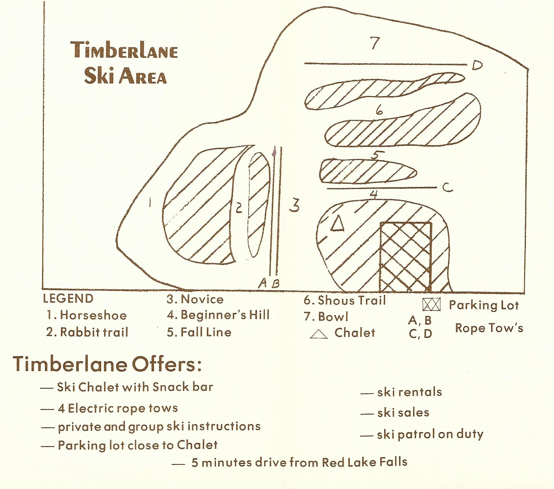
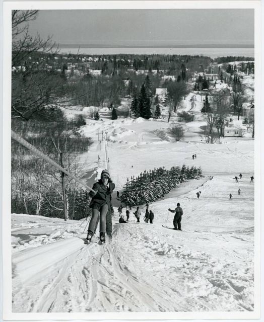
Timberlane
- Red Lake Falls, MN (Red Lake
County) - northwest Minnesota
- o: 1960 or 1961 (on
1961
map). c: 1979 (not on Nov.
1979
list) v: 110 ft.
- In 1978 (Skalka):
4 rope tows
- Google
Maps / Google
Earth
47.89774014032652, -96.30999328164717
- New
Area - Minneapolis Star,
Dec. 14, 1967
- Timberlane
Ski Report Excellent -
Grand Forks Herald (Grand Forks, North Dakota) ·
Fri, Jan 20, 1967
- advertisement
- Grand Forks Herald, Thu, Feb 04, 1965
- picture
- RLF
Snofest Opens Saturday -
Grand Forks Herald (Grand Forks, North Dakota) ·
Sun, Jan 30, 1966
- Vintage Video: Timberlane
Ski Area - Home Movies -
YouTube, late 1960s (4:12)
- RLF
Memories Facebook Page
- Minnesota
Outdoor Recreation Plan, 1965
- p. 251 (ERRORS: named "Timberland: and listed as Lake
County)
- Incorectly located on
1978
map. (Timberlane was about
10 miles north of US highway 2. The location on the 1978
map is for Ski
Devil Ski Area, Fertile,
MN.)
- skimap.org
ToMo
(Toad Mountain)
- Detroit Lakes, MN (Becker County)
- west central Minnesota (15 miles east of Detroit Lakes
on US 34)
- v: 300
- Google
Maps
/ Google
Earth (exact location
unknown)
46.86951926133622, -95.51206625395382
Toad Mountain, Toad Lake township
Please email - mark@mwlsap.org - if you know a more
precise location.
- In 1978 (Skalka):
1 rope tow, 4 chairlifts ??
Two
Harbors (probably
the same as Voyageur Skiway; may be the same as
Mt.
Silver)
- Two Harbors, MN (Lake County) -
northeast Minnesota (don't know exact location), 28 mi.
NE of Duluth
- Google
Maps / Google
Earth ???
( Town of Two Harbors)
47.03501246314212, -91.67445528911047
Please email - mark@mwlsap.org - if you know a more
precise location.
- Midwest
Ski Areas, Minneapolis
Tribune, Dec. 7, 1958, p. 52
- on 1958 and 1963 maps
- Minnesota
Outdoor Recreation Plan, 1965
- p. 251 (Voyageur Skiway)
- The American Ski Directory,
by William Pain, Permabook, 1961
Twin
Cities Army Ammunitions Plant
(TCAAP)
Tyrol
Ski Tow
- Same location as Mt.
Notch (1989)
- Avon, MN (Stearns County) - Hwy
52, 17 mi. W of St. Cloud (14 mi on Hwy 52, then left a
half mile before Avon, and go 3 mi)
- o: 1949 (may only have been open
only two seasons); 2 rope tows
- Google
Maps / Google
Earth ???
45.58268651659414, -94.45001853405277
Please email - mark@mwlsap.org - if you know a more
precise location.
- The
Fanning Mill - St. Cloud
Times (Saint Cloud, Minnesota) · Sat, Jan 1,
1949
- Tows
Ready For Skiers - St.
Cloud Times (Saint Cloud, Minnesota) · Thu, Dec 30,
1948
- Picture1
Picture
2 - St. Cloud Times (Saint
Cloud, Minnesota) · Mon, Jan 3, 1949
- Good
News: Tyrol Opens: "It's Tops" -
Star Tribune (Minneapolis, Minnesota) · Sun, Jan 9,
1949
- Upper
Midwest Ski Facilities Outlined
- Star Tribune (Minneapolis, Minnesota) · Sun, Jan
29, 1950
University
of Minnesota Duluth - also
called Rock Hill
- Duluth, MN (St. Louis County) -
northeast Minnesota
- WR Bagley Nature Center on the
University of Minnesota Campus
- v: 124 ft.
- Google
Maps / Google
Earth
46.822208358145694, -92.0893055790312
- Picture
- University of Minnesota Duluth Facebook
Page
- Picture
- UMD Libraries
Media
- skimap.org
(0 maps)
Val
Chatel
- Park Rapids, MN (Hubbard County) -
northwest Minnesota - 32546 County 4, Park Rapids,
MN
- v: 270 ft. o: 1953
- In 1978 (Skalka):
6 rope tows
- Google
Maps / Google
Earth
47.13382463098816, -94.97587366571594
- Second chairlift in Minnesota
(Single person chairlift closed before 1978.)
- Former
ski area in northern MN to become a park thanks to
anonymous donor - Melissa
Turtinen, March 22, 2022 , bringmethenews.com
- Val
Chatel: All that charm plus the best French fried onion
rings in Minnesota - SKIING
Magazine, Feb. 1968
- Val
Chatel Ski Lodge ca 1960 -
Ren Holland's Website
- Far
Side of Fifty - Val Chatel -
blogspot, July 31, 2010 post
- Minnesota
Outdoor Recreation Plan, 1965
- p. 251
- Viking
at Val Chatel: A Minnesota Legend
- adamkooyer.com
- Picture
in SKIING Magazine, Sept. 1969, p
159.
- Skiing
History Group -
Facebook
- skimap.org
Val
Croix+
- became Wild
Mountain, still
open
Val
Hulla ??
- Mankato, MN (Blue Earth) - south
central Minnesota
- on 1963 map
- Skiers
Take to Chartered Busses -
Minneapolis Star, Dec, 20, 1963
- The only reference found is the
Dec. 20, 1963 Minneapolis Star article and map. It is
doubtful that it actually existed.
Viking
Valley
Villa
Park (Villa-Arctic
Park?)
Voyageur
Skiway* (probably
the same as Two
Harbors and Mt.
Silver
MWLSAP
Homepage
WORKING
ON:
edinarealty_Star_Tribune_1973_06_28_Page_56.pdf
Columbia Park
https://www.mwlsap.org/minnesota/The_Minneapolis_Star_Sun__Feb_1__1942_.pdf
Mt
Lockness Ski Area - Mt. Lochness
Lost
Valley
- Lutsen MN - northeast
Minnesota
- Upper
Midwest Ski Facilities Outlined
- Star Tribune (Minneapolis, Minnesota) · Sun, Jan
29, 1950
- Maybe an early name for Lutsen
280-26 mi = 20 mi south of Sawtooth
Moundsview Ski Club
- Afton,
MN
- and north of New
Brighton
- was
originally TCAAP, then
moved to near Afton (near Hudson), MN, see Ski-Doodling
article
- Some
Skiing Notes by Pat Gould -
The Minneapolis Star (Minneapolis, Minnesota) · Fri,
Feb 24, 1939 - "north of New Brighton"
- Ski
Trails by Lloyd Borg - The
Minneapolis Star (Minneapolis, Minnesota) · Sun, Dec
15, 1940 ·
- Ski-Doodling
by Mel Larson - The
Minneapolis Star (Minneapolis, Minnesota) · Sun, Dec
21, 1941
- Why
Minneapolis Skiers Are Tops
- The Minneapolis Star (Minneapolis, Minnesota) ·
Sun, Feb 1, 1942
location of Crestwood
Golf and Ski
location of Edina
Ski Tow
location of Mt.
Florida
location of Mt.
Notch and Tyrol
Ski Tow
location of Mt.
Silver Silver
Creek?
location of New
Brighton Rope Tow* (probably
same as TCAAP)
location of Prior
lake Ski Area
- email sent to
info@scottcountyhistory.org
location of Royal
Oak
location of Rushford
location of Saint
Mary's College
location of Silver
Slopes
location of Skidahlen
location of Snofun
location of Snobakken
Ski Tow
location of ToMo
location of Two
Harbors
Lester-Amity
Park Ski and Jumping Area
Potter Ridge - probably Powder
Ridge
Deer
River ski hill
- WORKING
ON
- Deer River, MN (Itasca county) -
north central Minnesota
- Deer
River Finds Answer to Sports Program
Finances - The Winona Daily
News (Winona, Minnesota) · Thu, Aug 7,
1952
- no mention of tow
- Deer River Sliding Hill ???
Google
Maps
47.36472982780351, -93.7616420404384
- Itasca County Historical
Society
ichs@paulbunyan.net
Winter
Wonderland
- WORKING ON
- Little Falls, MN 4 mi SE of Little
Falls
- Little
Falls Host at Winter Wonderland
- St. Cloud Times (Saint Cloud, Minnesota) · Sat,
Jan 8, 1949
- St.
Cloud Unit to Appear at Wonderland
- St. Cloud Times (Saint Cloud, Minnesota) · Fri,
Jan 6, 1950
- Priest
focuses on youth to bring parishes closer
- St. Cloud Times (Saint
Cloud, Minnesota) · Tue, Jan 18, 1983
Lanesboro, MN and Pigeon Falls,
WI both ski jumps -
WORKING ON
- Voice
of the Outdoors - The
Winona Daily News (Winona, Minnesota) · Sat, Feb 4,
1950
- Benson Hill ski jump 2 mi N of
Lanesboro
Winter
Haven -
WORKING ON
MWLSAP
Homepage
Maple
Mountain
- Pelican Rapids,
MN
- Oasis
Survey Completion Assured by Funds
- The Daily Journal (Fergus Falls, Minnesota) · Thu,
Apr 11, 1968
- Enjoying
the Outdoors
- The Daily Journal (Fergus Falls, Minnesota) · Fri,
Sep 20, 1968
- "Maple
Mountain" Idea Near Pelican
Dropped -
The Daily Journal (Fergus Falls, Minnesota) · Tue,
Dec 17, 1968
- From Kathy Evavold
of the Otter Tail County Historical Society when asked
about the location of Ski
Dahlen:
- In materials I
looked at today, I have not been able to find the
location of Ski Dahlen on any maps. It may be
described in 1956 as, “a hill developed by Monson
a short distance west of the hill [,] facing
Lake Lida.”
This same 1956
newspaper article says that Hallaway
Ski Hill
Inc. became part of a new corporation known as
Hallaway-Ski Dahlen Inc.
For a time today
I had thought it was located further south, on land
owned by Philip Monson, but I am still not certain. In
a newspaper article from 1967, it is mentioned as part
of an article regarding the proposed development of
“Maple Mountain” which appears to have never
materialized. That article says, “the area will
include what was Ski-dahlen, with three hills to
provide runs up to 2400 feet. The vertical drop on the
hills is 225, 200, and 190 feet.” This project
was dropped after the accidental death of the person
who spearheaded the idea, and also with two other
large area fundraising projects going on. This area,
including Hallaway Ski Hill, became Maplewood State
Park, which was first proposed in
1961.
Afton
Alps
Andes
Tower Hills
- still OPEN
- Kensington, MN (Douglas County) -
west central Minnesota
- website
- skimap.org
Buck
Hill (formerly Gokey's
Hill)
Buena
Vista
- still OPEN
- Bemidji, MN (Beltrami County) -
north central Minnesota
- website
- skimap.org
Chester
Bowl Park
Coffee
Mill
Como
Park
Detroit
Mountain
- REOPENED [opened in 1958,
closed in 2004, reopened 2014]
- Detroit, Lakes, MN (Becker County)
- northwest Minnesota
- website
- skimap.org
Elm
Creek Winter Recreation Area
Giants
Ridge
Hyland
Hills Ski Area (formerly
called Hyland Ski and Snowboard Area and Mt.
Normandale)
Loppet Foundation Alpine Learning
Hill - see Theodore
Wirth Park
Lutsen
Mount
Itasca
Mount
Kato (formerly called
Anderson's Hill and Ski Haven)
Mount
Ski Gull
Pine
Valley Ski Area and Jump Center
Powder
Ridge Ski Area
Spirit
Mountain
- still OPEN
- Duluth, MN (St. Louis County) -
northeast Minnesota
- o: 1974
- website
- skimap.org
Steeplechase
Ski & Snowboard
Theodore
Wirth Park ( also called
Wirth Park, Mt. Wirth) now open as Loppet Foundation
Alpine Learning Hill
Welch
Village Ski Area
Wild
Mountain Ski Area
(formerly Val Croix)
MWLSAP
Homepage
|

Minneapolis
Tribune, Dec. 4, 1955, p. 52

Minneapolis Tribune, Dec.
7, 1958, p. 52

Minneapolis Tribune,Sun, Dec 6,
1959

Trollhaugen
Troll Facebook Page

Minneapolis Tribune, Dec.
17, 1961

Minneapolis Tribune, Dec.
23, 1962, p. 53


Minneapolis Star, Dec. 20,
1964, p. 62

Error: Timberlane located on map south of Bemidji
was actually in Red Lake Falls, 90 miles northwest of
Bemidji
Minneapolis Tribune, Dec.
13, 1964, p. 62


Star
Tribune (Minneapolis, Minnesota) · Sun, Nov 13, 1966
(information
on each ski area)

.jpg)
Minneapolis
Star (?) Mon. Nov. 16, 1969

Minneapolis
Star, Mon. Nov. 15, 1971, p. 2B (information
on each ski area)


Minneapolis Star, Nov. 10,
1972, p. 28 (information
on each ski area)


Minneapolis Star, Nov. 7,
1974 (information
on each ski area)

Winona Daily News, Sunday
Dec. 11, 1977 p. 25 (information
on each ski area)

Minneapolis Tribune, Nov.
20, 1977

Minneapolis Tribune, Nov.
19, 1978


St. Cloud Times,
Dec 8, 1978

Minneapolis Tribune, Nov.
9, 1980


Sugar
Hills
/ Quadna
- Ad in SKIING Mag, Spring 1969


|
